Loading video...

Video Failed to Load

Go Home

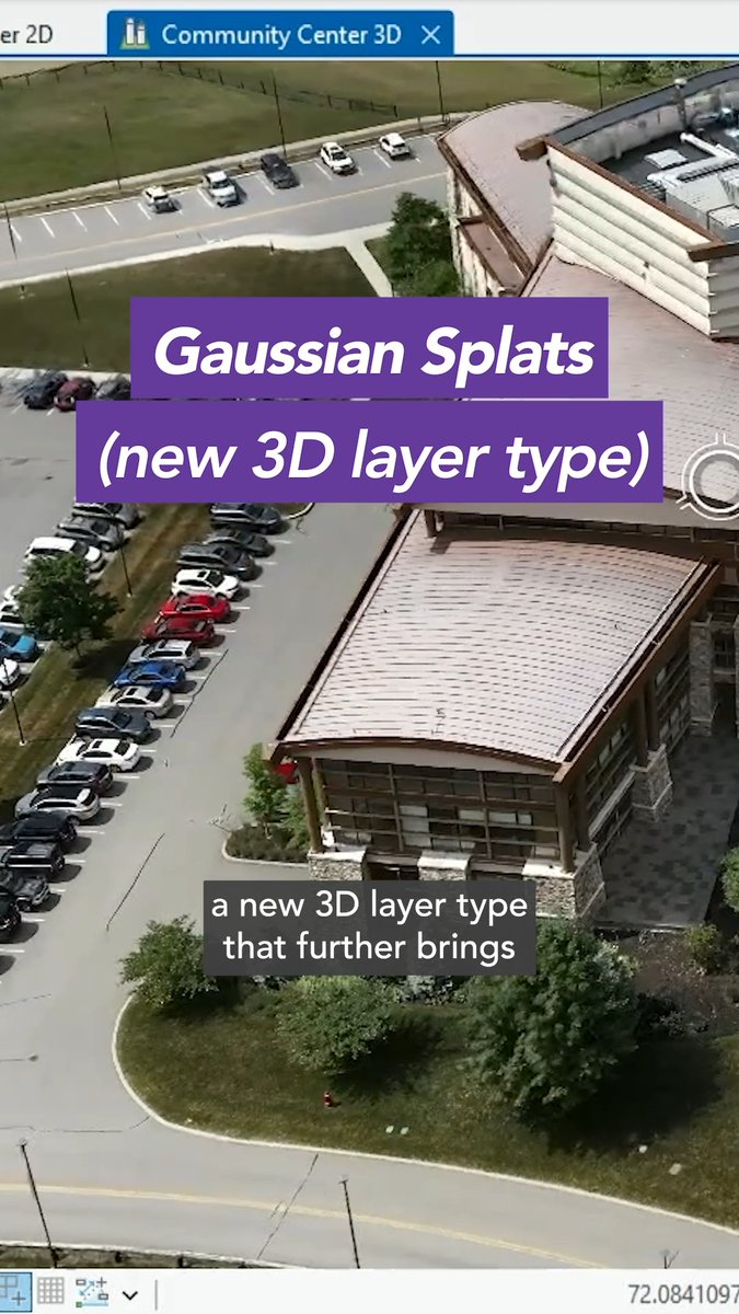
GeoLibre v0.5.0 is out! This update significantly expands data format support, making it easier to work with a wide range of geospatial datasets in a lightweight, modern GIS environment. Newly supported formats and services include: GeoJSON, Shapefile, GeoPackage, GeoParquet, KML/KMZ, FlatGeobuf, PMTiles MBTiles, GeoTIFF, Zarr, LiDAR point clouds, Gaussian...

18,730 views • 25 days ago •via X (Twitter)

0 Comments

No comments available

Comments from the original post will appear here

Related Videos

GeoLibre v1.2.0 is here! GeoLibre is a free and open-source, lightweight, cloud-native GIS platform for visualizing, exploring, and analyzing geospatial data. One application that runs everywhere: in your web browser, as a native desktop app, on your phone, and inside a Jupyter notebook. No account, no server, no cost. Everything runs locally and your data stays private. This release packs in 35+ pull requests of new capabilities. A few highlights: - Run SQL right in the browser. The SQL Workspace pairs DuckDB Spatial with a new in-browser PostGIS engine (PGlite), so you can query layers, local files, and remote URLs without a server. - A smarter attribute table. Add fields, run a field calculator, and explore your data with a built-in Charts panel (histogram, scatter, bar, line, and box plots). - More ways to add data. OpenStreetMap PBF extracts, Cloud-Optimized NetCDF/HDF via kerchunk, georeferenced video overlays, authenticated 3D Tiles, and a Layer builder for custom overlays. - Better visualization. Heatmap rendering, point clustering, and H3 hexagonal grids for spatial binning. - New analysis and routing. A Directions plugin, plus Spatial Join, Select by Value, and Select by Location vector tools. - Print and share. A print layout composer that exports your map to PNG or PDF. - Work faster. A command palette (Ctrl/Cmd + K), global keyboard shortcuts, and undo/redo for layer and style operations. - Built for everyone. New internationalization framework, an accessibility pass with automated axe checks, an installable offline-capable PWA web build, React error boundaries, and Playwright end-to-end tests. Try the live demo: Star it on GitHub: Docs and roadmap: Release notes: #GIS #OpenSource #Geospatial #MapLibre #WebGIS #DuckDB #GeoLibre

Qiusheng Wu

39,208 views • 11 days ago

GeoLibre v1.5.0 is here! GeoLibre is a free and open-source, lightweight, cloud-native GIS platform for visualizing, exploring, and analyzing geospatial data. It runs everywhere you do, in the web browser, on the desktop, on mobile, and inside Jupyter notebooks, all while keeping your data local and private. This release lands 90+ merged pull requests and resolves 90+ issues, adding a dashboard of chart widgets, customizable UI profiles, a saved library of web services, and an in-browser Whitebox raster engine. What's new in v1.5.0 - Dashboard panel: Build a collapsible panel of chart widgets (histogram, scatter, bar, line, box) next to the map. - Customizable UI profiles: Tailor the menus and filter the data sources you see, so the workspace matches your workflow. - Saved service library: Save and reuse your favorite web-service layers (XYZ, WMS, WFS) instead of re-entering URLs. - Whitebox in the browser: Run Whitebox raster tools fully client-side through a WASM runtime, no Python sidecar required. - View menu and viewport history: Step backward and forward through your recent map views from a new View menu. - A more beautiful globe: Add a spinning globe, customize the atmosphere halo and deep-space colors, and reset pitch and bearing with a rotation indicator. - More basemaps: New Protomaps basemaps and support for stacking multiple raster basemaps. Try it out - Live demo: - GitHub: - Documentation: - Release notes: #GIS #GeospatialData #OpenSource #RemoteSensing #DataVisualization #MapLibre #Python

Qiusheng Wu

38,390 views • 4 days ago