Video wird geladen...

Video konnte nicht geladen werden

Zur Startseite

Snow earlier this week = appetizer. Snow next week = MAIN COURSE. Check the forecast and monitor #QuickMap for real-time roadway information. More details here, CHP - Gold Run CHP Truckee CHP Donner Pass C.V.E.F. CHP Grass Valley CHP South Lake Tahoe CHP Placerville CHP Quincy

15,552 Aufrufe • vor 7 Monaten •via X (Twitter)

0 Kommentare

Keine Kommentare verfügbar

Kommentare vom Original-Post werden hier angezeigt

Ähnliche Videos

Elon Musk and X are shadow banning Turkey’s potential next president. Erdoğan government wants to silence Ekrem İmamoğlu and Elon Musk is helping them do it. İmamoğlu is currently in prison, and his legal case is still ongoing. Despite this, he remains the most popular presidential candidate in Turkey. And both Erdoğan and Elon seem intent on silencing him. Some time ago, İmamoğlu’s personal account was restricted in Turkey by court order. In response, CHP created a new account called “CB Candidate Office,” which isn’t personal but shares İmamoğlu’s messages. Even though there’s no official ban on the account, the following is happening: •Likes and retweets on posts are automatically deleted. The video below is my screen recording. While it looks like I’ve liked the most recent posts, it seems as if I’ve barely interacted with earlier ones, right? Only a few retweets in between. But I never retweet without like, and I click the like button for every single post from this account. I regularly go back and like posts I might’ve missed. Out of 136 total posts, it’s impossible that I’ve liked so few or only retweeted some. •The account’s follower count is not increasing. In the early days after launch, the account quickly reached 200,000 followers, but now the number is completely stagnant. Despite significant public interest, the follower count staying flat like this is abnormal. WITHOUT ANY LEGITIMATE REASON, ELON MUSK IS IMPOSING A SHADOW BAN ON THIS ACCOUNT. X MUST PUBLICLY EXPLAIN THE REASON BEHIND THIS BAN.

Duyk

203,005 Aufrufe • vor 1 Jahr

Wednesday February 11, 2026, 5:50 AM: Ferocious Siberian storm and deep central Pacific moisture axis arrive in Northern California on Sunday 6AM - Wednesday 9PM. Impactful widespread heavy rainfall 2.8 to 6.7 inches of rain for all SoCal, from San Luis Obispo to San Diego counties and that includes Northern California and Central California we all have impactful storm issues.  Bullseye heaviest severe impact is from Santa Barbara to Los Angeles Counties up to 3.7 to 8.5 inches of rainfall. This includes the Eaton fire burn scar zone and the Pacific Palisades burn scar zone. For the potential for higher confidence in mudslides. Accompanied by the storm are gusty powerful winds up to 65 MPH. Due to the cold nature of the system low elevation snowfall is projected at 2,500 feet least 2 - 6 inches expected this includes Antelope, Apple, and Lucerne valleys. Possible northernmost foothills of the Simi Valley, Santa Clarita, and San Fernando Valley. Still watching the details on the snow level for the northern valleys that’s still being looked at closely as a storm approaches in the next 24 to 36 hours so that part is not set in stone yet. Central and Northern California will have a 30% chance of sea level snowfall between Sunday afternoon and Sunday night. Higher confidence snowfall at 4,500 feet is projected to range from 6 to 12 inches of fresh powder. Higher accumulations of at 18 - 46 inches of snowfall in the local mountains of San Gabriel and San Bernardino starting at 5,500 feet Lake Arrowhead, Crestline, Big Bear may have a déjà vu moment of potential significant snow issues are trending be aware of this. This is just for cautionary purposes. Northern California Sierra Mountains: Truckee, Lake, Tahoe, Mount Shasta, and the Central Sierra’s of Yosemite and Mammoth Mountain will end up with 4 - 8 feet of snowfall if not isolated higher amounts are not out of the question. Strong winds gusting above 6,000 feet of 45 to 70 mph could cause whiteout conditions and deplorable travel conditions. The storm will have impacts on the five corridor Grapevine and Cajon Pass interstate 15 to Las Vegas please prepare for winter travel if you must travel expect closures and lengthy delays. Flooding will severely impact all freeways and highways and urban flooding is high confidence across much of Southern California, Central California, and Northern California, and is certain during this period. Please give yourself at least 2 to 3 hours before your travel time to work or school especially on Monday 6AM - 11AM This is critically important for the state of California. Trending confidence this is the biggest storm at this point to February 1 - 4, 2024, and February 24 - March 1, 2023, are the most recent trending similar storm impacts with this upcoming storm. Be safe everyone more detailed updates will continue over the next several days on this high-profile storm event. #CAwx #Califorinastorms J. Mesh, AMS 🇺🇸 SoCalWeather.net Rick Dickert L.A. in a Minute Ginger Zee Cece Woods SnowPals.org SF, CA 🌨️⛷️🏂 Drone Daddy News, OC Western Mogollon Rim Weather Josh Morgerman Rob Mayeda Edgar McGregor

Jason D Farhang

16,565 Aufrufe • vor 7 Monaten

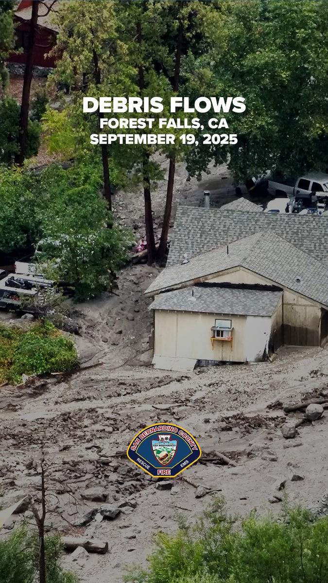
September Incident - Morning Incident Update The San Bernardino County Fire Protection District remains in unified command with CAL FIRE BDU on the September Incident. Overnight, crews remained committed to the incident. At this time, there are still no reported injuries or missing persons. We would like to thank all of our cooperating agencies for the strong collaborative effort demonstrated throughout this operation. Last night, Caltrans District 8 worked diligently to clear Highway 38, providing access to those who had been stranded on Highway 38. At this time, no known motorists remain stranded; however, assessment teams and field crews are continuing to search the area to ensure no other parties are in need of assistance. CAL FIRE, CHP Inland Division, SBCoPublicWorks, and other partners remain engaged in clearing roads and improving access. The SBCounty, San Bernardino County OES (Ready San Bernardino County) and California OES (California Governor's Office of Emergency Services) are also closely involved, and we are grateful for their early support in helping to accelerate the recovery process. With daylight, crews will gain a clearer picture of the full extent of damage to roads, infrastructure, and homes. San Bernardino County Fire’s Damage Assessment Team, along with San Bernardino County Building & Safety, will work throughout the day evaluating impacted structures and will assist in determining the extent of property loss. The National Weather Service (NWS San Diego) has forecast a chance of thunderstorms today in the San Bernardino County mountains and deserts. We urge all residents to avoid the affected areas of the September Incident. Conditions remain hazardous due to the potential for new slides, falling trees and utility poles, impassable roads, and dangerous debris. San Bernardino County Sheriff’s Aviation will be conducting aerial reconnaissance throughout the day and is equipped with hoist capabilities should rescue operations be necessary. The next update will be provided this evening unless significant changes occur.

San Bernardino County Fire

12,643 Aufrufe • vor 1 Jahr