
Ben Noll
@BenNollWeather • 94,478 subscribers
Global weather writer and meteorologist for @washingtonpost | Weather and climate analysis and visuals | #HudsonValley snow days
Shorts


Videos

A remarkable 3.5˚C rise in central equatorial Pacific Ocean temperatures is possible by November, shows new ECMWF, which would mark the strongest El Niño on record. Possible strength scenarios range from +2.8˚C to +4.3˚C, with sweeping consequences on global climate into 2027.
Ben Noll528,906 次观看 • 1 个月前

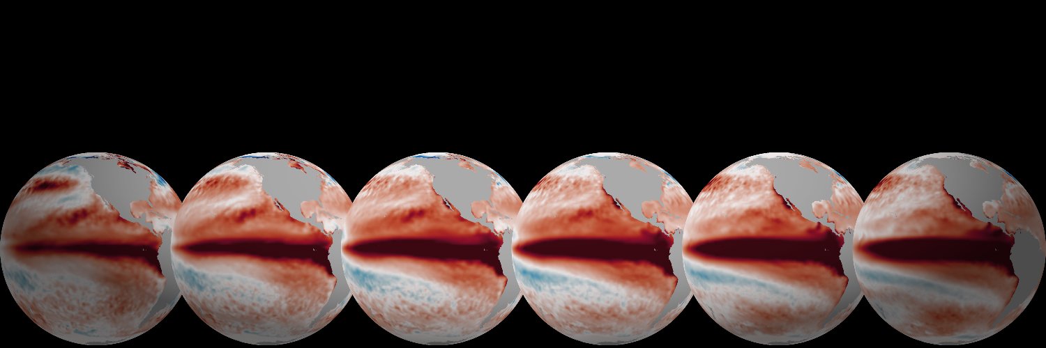
2026 and 1997 are El Niño twins. But they didn't always look alike. Subsurface ocean warmth developed faster in 1997, but 2026 caught up following a record-breaking Kelvin wave that formed in April. A new westerly wind burst into June will keep these two years neck and neck.
Ben Noll191,750 次观看 • 1 个月前


The amount of water vapor pulsing across our skies set a record in 2024. So far, 2025 is on pace to top that record. A novel analysis in today's The Washington Post, called floods above, dives deep into changing integrated vapor transport — and areas vulnerable to these changes 🧵
Ben Noll195,295 次观看 • 8 个月前

A freight train of warm water chugging beneath the surface of the Pacific Ocean is a big reason why a super El Niño may form this year. Ocean waters have peaked around 7.5˚C (13.5˚F) above average, breaking records. And now, it's nearing the western shores of South America 🧵
Ben Noll54,912 次观看 • 2 个月前


Guess who's back, back again. La Niña's back, tell a friend. For the fifth time in six years, La Niña is back. Is the La Niña trend being influenced by rising global temperatures? Given how important El Niño and La Niña are to weather patterns, it's critical to figure this out!
Ben Noll142,163 次观看 • 9 个月前


A sizable surge of tropical moisture will set the stage for possible flooding downpours this weekend and next week across the South and East. There's long-distance moisture flowing from the Pacific, where El Niño-related warmth is building, as well as the Gulf and Caribbean.
Ben Noll16,875 次观看 • 2 个月前


#HudsonValley: flooding, wind damage likely tonight, may cause school delays/closings on Wednesday 😵💫 Before the rain, 1-3 inches of wet snow in Sullivan and western Ulster County between noon - 4:00 pm may cause early dismissals or lead to the cancellation of after-school activities. Elsewhere across the mid-Hudson Valley, any wet snow that falls this afternoon is unlikely to stick to paved surfaces. After 4:00 pm, the main precipitation type will be rain, and it’s expected to become heavy in the evening. The forecast for Tuesday night and early Wednesday morning is a tumultuous one: - Periods of heavy rain and maybe even a thunderstorm between 6:00 pm - 3:00 am, with rainfall amounts ranging from 2-4 inches (a month’s worth or more) - Rapid snow melt, especially when the temperature reaches the low-to-mid 50s after midnight - Strong-to-damaging wind gusts of 40-60 mph between 6:00 pm - 3:00 am Possible impacts include: - Ponding of water and flooding on streets, particularly in urban and low-lying areas - Flooding of rivers, creeks, and streams, some of which may rise out of their banks - Scattered-to-widespread power outages and downed tree branches; the combination of sodden grounds and strong winds may cause some trees to topple If you live in a flood prone location, expect flooding tonight — take extra steps to protect your property. Some school delays and/or closings will likely occur on Wednesday because of this storm, although it isn’t possible to pinpoint exactly which towns will experience the worst impacts. The December 18th storm is comparable to this storm, although the flooding and wind damage chance looks higher this time around. Although the worst of the weather will be over by daybreak Wednesday, strong wind gusts of 30-40 mph are expected on Wednesday afternoon, affecting cleanup efforts. Another significant rain and wind storm is likely on Friday night.
Ben Noll39,323 次观看 • 2 年前

没有更多内容可加载