
Tomer Burg's banner
Tomer Burg's profile picture

Tomer Burg

@burgwx • 55,874 subscribers

Senior meteorological scientist at @WindBorneWx & web developer. Personal account

Shorts

Typhoon Champi's journey from a pinhole eye to a massive category 5 super typhoon:

Typhoon Champi's journey from a pinhole eye to a massive category 5 super typhoon:

30,052 views

With a record strong El Niño underway, the East Pacific has seen an impressive record-shattering stretch of hurricane activity in the last few weeks. Going through some impressive statistics of just how historic it's been in this thread:

With a record strong El Niño underway, the East Pacific has seen an impressive record-shattering stretch of hurricane activity in the last few weeks. Going through some impressive statistics of just how historic it's been in this thread:

69,884 views

The Big Island of Hawaii certainly dodged a close call with Hurricane Nolo. While the prolonged easterly fetch did lead to heavy rain on the eastern side of the island, a farther north storm would've led to far more significant impacts from a near-stationary hurricane.

The Big Island of Hawaii certainly dodged a close call with Hurricane Nolo. While the prolonged easterly fetch did lead to heavy rain on the eastern side of the island, a farther north storm would've led to far more significant impacts from a near-stationary hurricane.

68,605 views

Through extraordinary efforts, WindBorne Systems successfully navigated a controllable balloon above powerful Typhoon Dolphin, descended into its eye, then collected multiple vertical profiles as we circled inside its eye. A first of its kind type of hurricane data collection.

Through extraordinary efforts, WindBorne Systems successfully navigated a controllable balloon above powerful Typhoon Dolphin, descended into its eye, then collected multiple vertical profiles as we circled inside its eye. A first of its kind type of hurricane data collection.

78,565 views

The Predecessor Rain Event (PRE) associated with Hurricane Helene can be visualized with radar & mid-troposphere heights (blue lines). Helene's interaction with a cutoff low brought a frontal boundary to a stall over western NC with a deep moisture plume well ahead of Helene:

The Predecessor Rain Event (PRE) associated with Hurricane Helene can be visualized with radar & mid-troposphere heights (blue lines). Helene's interaction with a cutoff low brought a frontal boundary to a stall over western NC with a deep moisture plume well ahead of Helene:

445,878 views

While the East Pacific is experiencing one of its most active hurricane seasons on record, the Atlantic is the polar opposite, so far having its quietest season in the satellite era (1960s-present). The "Main Development Region (MDR)" has been, well, a Mostly Dead Region.

While the East Pacific is experiencing one of its most active hurricane seasons on record, the Atlantic is the polar opposite, so far having its quietest season in the satellite era (1960s-present). The "Main Development Region (MDR)" has been, well, a Mostly Dead Region.

21,168 views

MRMS radar reflectivity & HRRR precipitation type over the last 24 hours. An absolutely massive storm

MRMS radar reflectivity & HRRR precipitation type over the last 24 hours. An absolutely massive storm

149,161 views

In an all-too-familiar theme this month, here's a loop of SPC storm reports from the latest round of active severe weather across the US over the last week:

In an all-too-familiar theme this month, here's a loop of SPC storm reports from the latest round of active severe weather across the US over the last week:

322,619 views

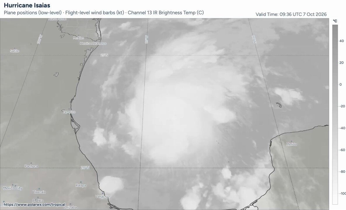
Isaias is now the first hurricane of the 2026 Atlantic season & is expected to intensify further today as it approaches the US gulf coast. NOAA & the US Air Force have been flying plenty of recon flights to help with analysis and forecasting, data which is also fed into models.

Isaias is now the first hurricane of the 2026 Atlantic season & is expected to intensify further today as it approaches the US gulf coast. NOAA & the US Air Force have been flying plenty of recon flights to help with analysis and forecasting, data which is also fed into models.

13,086 views

I've made numerous animations of extreme mesoscale flash flooding events in recent years -- August 2021 in Tennessee, Hurricane Ida in NJ, just to name a few. None have been as extreme in intensity *and* duration as what occurred in Fort Lauderdale, FL yesterday.

I've made numerous animations of extreme mesoscale flash flooding events in recent years -- August 2021 in Tennessee, Hurricane Ida in NJ, just to name a few. None have been as extreme in intensity *and* duration as what occurred in Fort Lauderdale, FL yesterday.

216,528 views

Discrete tornado-producing supercells, derecho with a textbook bookend vortex & rear inflow jet development, MCS-supercell mergers... this is one of the most meteorologically impressive radar loops I've put together.

Discrete tornado-producing supercells, derecho with a textbook bookend vortex & rear inflow jet development, MCS-supercell mergers... this is one of the most meteorologically impressive radar loops I've put together.

76,701 views

This is certainly a day to save radar loops and weather observations from the Deep South - we're witnessing an incredibly rare historic event right now. Snowstorms like this don't come often at all - in fact, only a few since the late 1800s.

This is certainly a day to save radar loops and weather observations from the Deep South - we're witnessing an incredibly rare historic event right now. Snowstorms like this don't come often at all - in fact, only a few since the late 1800s.

85,436 views

A quick look at SPC storm reports from the highly active - and unfortunately devastating - stretch of severe weather over the last week that is still ongoing:

A quick look at SPC storm reports from the highly active - and unfortunately devastating - stretch of severe weather over the last week that is still ongoing:

49,565 views

What on earth did I just witness #AMS2026

What on earth did I just witness #AMS2026

13,429 views

An intense MCS developed in Colorado yesterday, propagating into Oklahoma where an intense segment produced a swath of 70+ mph wind through the Tulsa metro area. Here's a loop of the MCS evolution, along with SPC wind reports:

An intense MCS developed in Colorado yesterday, propagating into Oklahoma where an intense segment produced a swath of 70+ mph wind through the Tulsa metro area. Here's a loop of the MCS evolution, along with SPC wind reports:

15,682 views

Videos

No more content to load