
Kyle Walker
@kyle_e_walker • 19,265 subscribers
Geospatial, AI, open source. Building: https://t.co/LK0sd3EBsx
Shorts


Videos


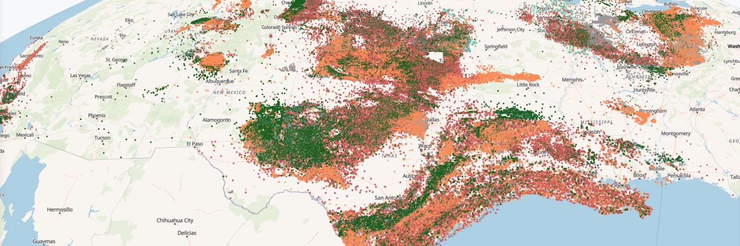
My most popular post of the year: mapping 1.7 million Texas oil & gas wells with zero performance lag. Draw a lasso, instantly query operators. There are so many opportunities for advanced GIS + AI to impact oil and gas, helping operators, mineral buyers, brokers, and more.
Kyle Walker542,801 Aufrufe • vor 6 Monaten


Nearly 800 swimming pools identified from Mapbox satellite imagery with Meta's SAM3 in a section of Beverly Hills. In the soon-to-be-released {geosam} R package: review results by confidence level, filter, then export. This is shaping into a tool for serious applied work.
Kyle Walker285,468 Aufrufe • vor 7 Monaten

I configured my OpenClaw bot to fetch the most recent drilling permits from the Texas Railroad Commission. It grabs the permits, parses the data, maps them over satellite imagery, and sends them over to me via Telegram. The opportunities for AI + GIS in oil and gas are massive.
Kyle Walker180,298 Aufrufe • vor 4 Monaten

Showed my Advanced GIS students Claude Code this week. We built this map of code compliance violations in Fort Worth; heatmap giving way to points on zoom. Used the ArcGIS SDK for JavaScript. Took 10 minutes. Faculty need to be teaching skills for 2026, not for 2016.
Kyle Walker177,355 Aufrufe • vor 5 Monaten


There's so much focus on "how can AI do my work for me?" I think the more important question is "what work can I now do with AI that I would have never attempted before?" Earlier this year I wrote freestiler, a vector tiling engine for R and Python, with the help of Claude and Codex. I knew what the ideal engine looked like and how it would work at a high level. I didn't know how to put it together, and I don't know Rust, the language I wanted under the hood. Previously I would never have attempted this project as the ROI wasn't there. It would have taken me a year or more to learn the internals of a vector tiling engine and enough Rust to implement one. With Opus-level models, I could take it on. freestiler now powers all my vector tiling pipelines, including the map below rendering 143 million jobs from LODES, and it has 114 GitHub stars. Building this way has required a different set of skills. I don't review the code line by line. I set up adversarial agents to do that and write the test suites. What I review is the architecture, the behavior, and the results. Agent teams surface findings and explain their reasoning; I evaluate and critique. My job isn't to stress over code formatting, but instead to focus on questions like whether the engine is designed right, whether the output is correct, and if the UX makes sense. This means that I haven't "replaced my work." I've taken on entirely new work, with the help of agents, that I would have never done otherwise. It has taken some getting used to shipping code I haven't personally typed. In the old way of working, I built understanding through writing that code. Now I build understanding through managing the project - writing a spec, reviewing structure, evaluating UX. And that's helped me think a whole lot bigger in terms of what I can now do.
Kyle Walker13,396 Aufrufe • vor 12 Tagen


Gemini has always been my go-to LLM for document extraction - but accurate bounding boxes with agentic vision are a huge value-add in the latest Gemini models. Shown: extracting structured data from an oil & gas lease in Ector County Texas with the best bboxes I've seen yet.
Kyle Walker79,632 Aufrufe • vor 4 Monaten


1,890 swimming pools found across a 5 square mile suburban neighborhood with zero-shot image segmentation. Lower the confidence threshold to find even more! Use the interactive explorer in the {geosam} R package to try out Meta's SAM3 for satellite imagery analysis yourselves.
Kyle Walker50,458 Aufrufe • vor 3 Monaten


All 8.1 million US Census blocks. Visualized smoothly in 3D. Instant population and housing totals from a lasso selection. All running seamlessly in the browser, no traditional backend. While everyone’s talking about AI, it’s an incredible time for geospatial tech.
Kyle Walker106,842 Aufrufe • vor 9 Monaten