正在加载视频...

视频加载失败

DEVASTATING 💔 Pinellas County battled multiple fires early Thursday morning, particularly in coastal neighborhoods. Firefighters couldn't access many of them because of flooding. It comes as downed power lines cause outages across Tampa Bay:

355,529 次观看 • 1 年前 •via X (Twitter)

9 条评论

DB Houstonian 的头像
DB Houstonian1 年前

Sad they couldn’t have anticipated it Abd cut gas and power for 18 hours

Andy Hollis 的头像
Andy Hollis1 年前

Many fires like this are caused by rising waters from storm surge that cause electrical shorts in outlets when homeowners don't cut the power at their breaker boxes before evacuating.

Elizabeth🕉️♏🏳️‍🌈🌊 的头像
Elizabeth🕉️♏🏳️‍🌈🌊1 年前

A preemptive power shutdown may have helped. Tragedy on tragedy. 😔

✨Jaded@ 的头像
✨Jaded@1 年前

A HUGE SHOUT OUT to wfla first responders, fire fighters, rescue work and ALL Florida's residents, and Gov. Ron Desantis. This one was a doozy

Gators Parasail 的头像
Gators Parasail1 年前

Devastating it is

liberalease 的头像
liberalease1 年前

This happened in NYC after Superstorm Sandy. 132 houses burned down that night. They should cut power before these storms.

The Mrs. that makes popcorn on the stove 的头像
The Mrs. that makes popcorn on the stove1 年前

Ok when storm is about to hit, why don’t the electric companies shut the power off to avoid the electrical fires like this?

Patient Safety Day 的头像
Patient Safety Day1 年前

According to @GovRonDeSantis everything is under control

Comsen 的头像
Comsen1 年前

Why was there flooding and downed power lines yesterday way before the hurricane?

相关视频

#HudsonValley: flooding, wind damage likely tonight, may cause school delays/closings on Wednesday 😵‍💫 Before the rain, 1-3 inches of wet snow in Sullivan and western Ulster County between noon - 4:00 pm may cause early dismissals or lead to the cancellation of after-school activities. Elsewhere across the mid-Hudson Valley, any wet snow that falls this afternoon is unlikely to stick to paved surfaces. After 4:00 pm, the main precipitation type will be rain, and it’s expected to become heavy in the evening. The forecast for Tuesday night and early Wednesday morning is a tumultuous one: - Periods of heavy rain and maybe even a thunderstorm between 6:00 pm - 3:00 am, with rainfall amounts ranging from 2-4 inches (a month’s worth or more) - Rapid snow melt, especially when the temperature reaches the low-to-mid 50s after midnight - Strong-to-damaging wind gusts of 40-60 mph between 6:00 pm - 3:00 am Possible impacts include: - Ponding of water and flooding on streets, particularly in urban and low-lying areas - Flooding of rivers, creeks, and streams, some of which may rise out of their banks - Scattered-to-widespread power outages and downed tree branches; the combination of sodden grounds and strong winds may cause some trees to topple If you live in a flood prone location, expect flooding tonight — take extra steps to protect your property. Some school delays and/or closings will likely occur on Wednesday because of this storm, although it isn’t possible to pinpoint exactly which towns will experience the worst impacts. The December 18th storm is comparable to this storm, although the flooding and wind damage chance looks higher this time around. Although the worst of the weather will be over by daybreak Wednesday, strong wind gusts of 30-40 mph are expected on Wednesday afternoon, affecting cleanup efforts. Another significant rain and wind storm is likely on Friday night.

Ben Noll

39,323 次观看 • 2 年前

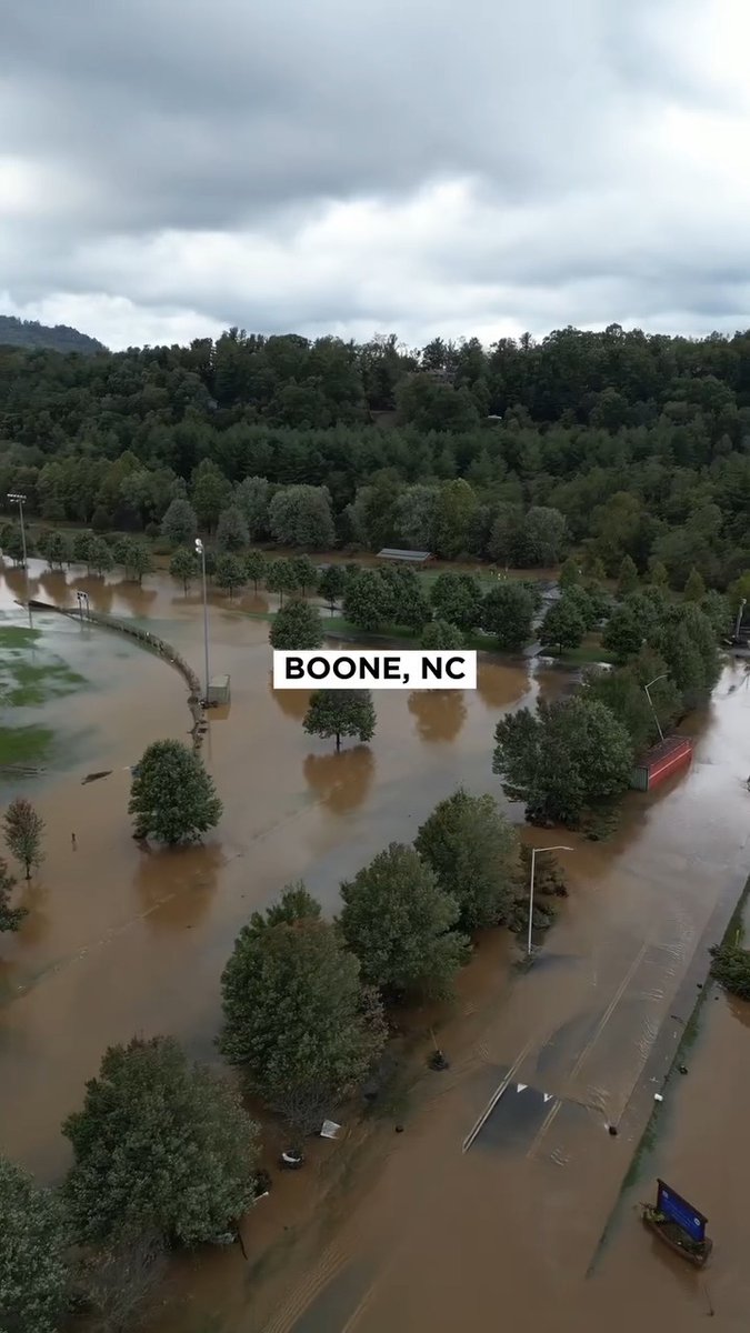
As the damage and various needs brought on by Hurricane Helene continue to unfold, Samaritan’s Purse is currently responding in five locations across the U.S. while coordinating with local authorities and assessing the damage in multiple locations. In Florida, our teams are based in Perry and the greater Tampa area, where homes have been severely flooded after Hurricane Helene made landfall as a Category 4 storm. We are also responding in Valdosta, Georgia to help suffering families as they begin their long road of recovery, Boone, North Carolina—home to the Samaritan’s Purse international headquarters—and a large swath of surrounding communities have been particularly hard-hit with toppled trees, flash flooding, road damage, and lack of power and water. We have established a response throughout western North Carolina and are also assisting area hospitals by providing oxygen support for those who have lost power and require the use of oxygen for medical needs. We’ve set up a two-tent unit in the parking lot of Watauga County Medical Center as well as one in Linville at the Cannon Memorial Hospital. You can find more details about our response and how you can volunteer at Please prayerfully consider serving as many volunteers will be needed to serve as the hands and feet of Jesus Christ to help the hurting. For additional details and updates regarding our response, please visit and continue to monitor our social media channels for important updates.

Samaritan's Purse

148,112 次观看 • 1 年前