Loading video...

Video Failed to Load

Go Home

๐Ÿ”ฅ INTENSE VIEWER VIDEO ๐Ÿ”ฅ This dramatic video shows flames burning on both sides of SR-36 as an evacuation order was issued for the Lofgren area because of the fast-moving Maple Peak Fire. Maddie Cloward shared the video of her husband escaping from their cabin near Lofgren in the...

22,442 views โ€ข 2 months ago โ€ขvia X (Twitter)

0 Comments

No comments available

Comments from the original post will appear here

Related Videos

Fire activity has increased exponentially on the north side of the #Widemouth2Fire. Based on a flyover, the fire is approximately 10,300 acres. The flareups that occurred earlier spotted over the north line and northeast line, closest to Turkey Track Lane and Cemetery Road. Fire is also pushing north to Highway 91. Everything south of 300 S is in GO evacuation status. The sheriff's office went door to door evacuating residents. Highway 133 is closed at the Kanosh city perimeter, except to residents. Highway 91 is closed to I-15. The fire has crossed Kanosh Canyon and established on the north side of the canyon. It's making a fast push northward, along the forest boundary. The IMT and sheriff are in discussions on further evacuations based on changing fire conditions. Fire behavior is extreme, with long distance spotting. This threat is real to the evacuated areas. We will have no weather reprieve, and the winds area predicted to continue from the south throughout the night. We will keep crews engaged with both aggressive fire suppression, as well as structure protection, throughout the night. More resources are on their way to assist, both ground and air support. Based on current fire behavior, the Millard County Sheriff's Office upgraded the evacuation levels: ๐Ÿ”ด๏ธTurkey Track Lane and Cemetery Road, and residents south of 300 S. are in "GO" status ๐ŸŸก The town of Kanosh north of 300 S. is in "SET" The spring feeding the city has been shut down. We're asking the residents to conserve water to avoid depleting the city tanks. Please follow all evacuation recommendations. Everyone except residents should avoid the Kanosh area to alleviate traffic, as residents evacuate and more fire traffic arrives to assist. We will continue to post updates on the emerging situation.

Utah Fire Info

15,706 views โ€ข 26 days ago

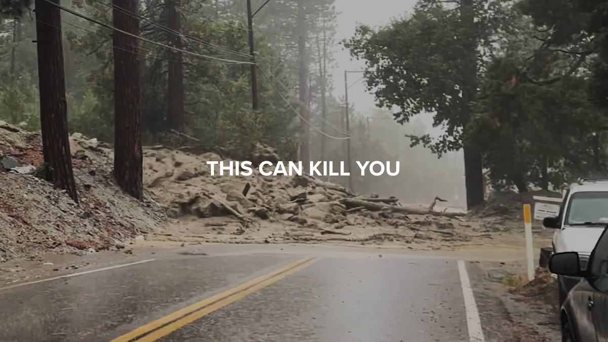
Now is the Time to Prepare for Floods. Safety Starts with You. SAN BERNARDINO COUNTY, CA โ€“ With rain finally on the horizon, the San Bernardino County Fire Protection District is calling on residents to take proactive steps to protect their families, homes, and communities. The risks of severe weather underscore the importance of being ready before a storm hits, particularly in wildfire burn-scarred areas like Bear Canyon near Mount Baldy. Mud and debris flows pose a significant threat in areas impacted by recent wildfires, including the Line Fire and the Bridge Fire. Loose rocks, dirt, and burned debris on hillsides can quickly turn into destructive torrents during heavy rain, endangering lives and property. While efforts have been made to reduce these risks, including investments in mitigation projects, personal preparedness remains critical. โ€œWe can only prepare so much,โ€ said San Bernardino County Fire Division Chief Jim Topoleski. โ€œItโ€™s essential for homeowners, residents, and recreationists to take evacuation warnings seriously and to have a plan in place before disaster strikes.โ€ San Bernardino County Fire urges residents to take these key steps: 1๏ธโƒฃ Stay Informed: Sign up for local emergency alerts at Monitor weather forecasts and advisories regularly. 2๏ธโƒฃ Create an Emergency Plan: Develop a family emergency plan, including evacuation routes and communication strategies. Practice the plan with your household. 3๏ธโƒฃ Assemble a Disaster Kit: Include essentials such as water, non-perishable food, first aid supplies, medications, flashlights, batteries, and important documents. 4๏ธโƒฃ Protect Your Property: Clear drainage systems, gutters, and nearby storm channels of debris. Use sandbags to redirect water flow away from your home. 5๏ธโƒฃ Follow Evacuation Orders: If authorities issue an evacuation order, leave immediately to ensure your safety and that of emergency responders. To illustrate the dangers of mud and debris flows and the importance of preparation, Division Chief Jim Topoleski shares his insights from Bear Canyon in the Mt Baldy Area. In the video, Chief Topoleski highlights the risks posed by storm runoff and encourages residents to act now to reduce potential impacts. By taking steps today, you can protect yourself, your family, and your community from the unpredictable forces of nature. Visit for resources on creating emergency plans, signing up for alerts, and staying informed.

San Bernardino County Fire

11,791 views โ€ข 1 year ago

A bag for life? In an airplane emergency evacuation, you should not bring your carry-on luggage. This is not a suggestion. It is a life-saving principle. Hereโ€™s why: 1. It slows down the evacuation. An evacuation is designed to be completed in 90 seconds or less. Every second matters. Opening overhead bins, pulling bags out, and maneuvering them down the aisle creates congestion and blocks exits. 2. It endangers other passengers. A narrow aisle becomes impassable when even a few people stop to retrieve luggage. Those behind may be trapped in smoke, fire, or toxic fumes with no way forward. 3. It can damage evacuation slides and rafts. Cabin baggage can puncture or tear slides. If a slide fails, an entire exit becomes unusable. That directly reduces survival chances for everyone on board. 4. It increases the risk of injury. Bags can strike people in the face, hit children, or cause passengers to fall while exiting. In a high-stress environment, even small obstacles become dangerous. 5. It shows disregard for crew authority. Cabin crew are trained to shout commands like โ€œLeave everything!โ€ for a reason. In some cases, they are trained to physically remove bags from passengers if necessary because the risk is that serious. Now consider two real-world scenarios: The 2019 crash of Aeroflot SSJ-100 Flight 1492 The aircraft made an overweight emergency landing in crosswind and windshear conditions after lightning strike and loss of key electrical systems. It bounced three times. On the third impact, the main landing gear collapsed, punctured the wing, and caused a major fuel spill and fire. Only 37 of the 78 occupants survived. Forty-one died. The final report blamed several passengers for retrieving cabin baggage from overhead bins during evacuation. While difficult to quantify exactly, it almost certainly slowed the process in a rapidly worsening fire. In a post-crash fire, seconds determine survival. On 2 January 2024, a Japan Airlines Airbus A350 was engulfed in flames after a runway collision in Tokyo. The cabin quickly filled with smoke, and the fire intensified outside. All passengers followed crew instructions and left their baggage behind. All 379 passengers and crew evacuated successfully. No fatalities. No serious injuries. The difference was discipline and strict adherence to instructions. If passengers are determined to take baggage, there is very little cabin crew can realistically do in the chaos. That is why passenger behaviour is critical. So letโ€™s settle this: No bag is worth a life. Not yours. Not someone elseโ€™s. In an evacuation, leave everything behind and get out.

Turbine Traveller

52,433 views โ€ข 5 months ago

The #Widemouth2Fire has been pushing north towards Fillmore, UT since last night. The fire is currently mapped at 36,438 acres, but has grown since then that mapping mission. With the predicted wind, the fire will likely continue to grow north and northeast. Strong winds are expected to remain active throughout the night. Crews remain fully engaged and are aggressively working to suppress the head of this fire. Fire managers are working continuously with the Sheriff on changing conditions and evacuation needs. On the perimeter east of Meadow, the fire continues to progress towards the ridge, but has not crested yet towards I-70. Crews are scouting around I-70 beyond that existing fire front, to make a strategic plan for future suppression activities. Due to the inaccessibility of the area, and changing wind conditions, no crews have been inserted yet on the eastern side. Crews continue to secure and hold the south and southwestern perimeter of the fire, south of Kanosh, UT. Thus far, these edges are holding with very little heat and growth. There are still some internal smokes with potential for spotting, so firefighters are working diligently to mop up well within the perimeter to avoid any slop overs or spotting. Residents are asked to stay close to their phones for evacuation changes. Any changes will be sent out on an alter to phones and homes within the perimeter of the evacuation zones. If moved into โ€œGOโ€, officers will go door-to-door to evacuate residents. Please follow the Millard County Sheriff's Office Facebook page for current evacuation updates and information. Video of the recon flight earlier today

Utah Fire Info

20,666 views โ€ข 25 days ago

Sandy Fire Air Monitoring Update - Due to the Sandy Fireโ€™s proximity to the Santa Susana Field Laboratory (SSFL), hazardous materials and radiological monitoring teams continue proactive air quality and radiation monitoring operations around the fire area. Currently, seven air sampling radiological monitoring locations have been established surrounding the incident, including the Chatsworth, Lake Manor, Bell Canyon, Oak Park, and Simi Valley areas. These monitoring systems are being used to establish background environmental conditions and to continuously evaluate smoke and air quality conditions as firefighting operations continue. The Sandy Fire has NOT reached the Santa Susana Field Laboratory property, and there is currently no indication that any radiological material has been released from the site. The attached drone video shows the current fire perimeter in relation to the SSFL area. Public health and environmental agencies, including Ventura County Public Health, the Los Angeles County Department of Public Health, California Department of Toxic Substances Control (DTSC), Ventura County Air Pollution Control District, and the U.S. Department of Energy, remain actively engaged in monitoring conditions and supporting incident operations. The U.S. Department of Energy is supporting air monitoring operations around the SSFL out of an abundance of caution. Radiation measurements collected as recently as 2025, along with modeling conducted following the 2018 Woolsey Fire, continue to indicate that the extremely low levels of residual radioactive material at the site pose no risk to public health, even in the event wildfire activity reaches the area. The SSFL is located in an area historically prone to wildfires, including the 2018 Woolsey Fire. Following that fire, air, soil, and ash sampling conducted by DTSC did not detect the release of chemical or radiological contaminants from the site. Additionally, radiological assessments conducted by the Los Angeles County Department of Public Health found no discernible levels of radiation in tested areas surrounding the site. Residents can continue monitoring local smoke and air quality conditions using the AirNow Fire and Smoke Map: About the video: The background map shows the drone location as a circle with a blue arrow. The blue line shows the flight path of the drone, while the moving polygon represents the area the drone camera is viewing. The left screen displays the thermal imaging view, and the right screen shows the normal video footage. This video demonstrates that the fire did not reach the Santa Susana Field Laboratory property. Los Angeles County #LAFD Talk ๐Ÿ’ฌ County of Ventura SVPD City of Simi Valley Ventura County Sheriff

VCFD PIO

20,835 views โ€ข 3 months ago