正在加载视频...

视频加载失败

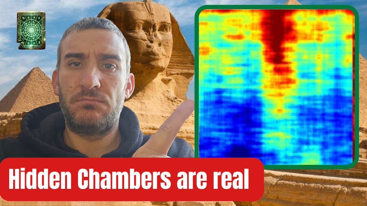
LATEST UPDATE: Recent developments regarding the Synthetic Aperture Radar (SAR) scanning of the Giza Plateau have revealed significant findings beneath the Khafre Pyramid. The Italian-led team, including Filippo Biondi, has uncovered extensive subterranean structures using SAR technology, which enables 3D imaging without on-site access. This method has previously been...

42,668 次观看 • 1 年前 •via X (Twitter)

4 条评论

MotoFlyy 的头像
MotoFlyy1 年前

@TrentTelenko I got a bridge in Brooklyn to sell you...

Dr Shad Katuu 🌐 的头像
Dr Shad Katuu 🌐5 年前

Overview of the InterPARES Trust Project in Africa: Trusting Records in an Increasingly Networked Environment #Archives #DigitalRecords #InternationalResearch #InterPARES #RecordsManagement

Marta 的头像
Marta1 年前

None of this makes any sense.

Aaron 🏃🏼‍♂️✨ 的头像
Aaron 🏃🏼‍♂️✨1 年前

next step independent verification 🤷🏼‍♂️

相关视频

🚨#BREAKING EGYPT STAIRCASES TO THE PRE FLOOD ERA as HUGE STRUCTURES are Discovered 2km BELOW Pyramid of Giza! Synthetic Aperture Radar Doppler Tomography Reveals Details of Undiscovered High-Resolution Internal Structure of the Great Pyramid of Giza A research team consisting of Corrado Malanga, Armando Mei, Filippo Biondi, and Nicole Ciccole has released new findings from a SAR (Synthetic Aperture Radar) scan conducted on the Giza Plateau, focusing specifically on the underground structures beneath the Khafre Pyramid. This work is part of the ongoing Khafre Research Project, which leverages advanced satellite technology to explore the site’s hidden architecture. A mysterious L-shaped structure has been observed underground in the western cemetery of Giza. Known as the Cemetery of the Nobles or the Cemetery of the Pyramid Builders, it is an ancient burial ground located on the western bank of the Nile River, near the famous Giza pyramids in Egypt. The team used remote sensing technology to detect remains in the underlying structure. This cemetery served as the final resting place for individuals who held significant roles in ancient Egyptian society, including officials, administrators, and artisans involved in the construction of the pyramids. To look for more remains in the area, the team used electrical resistivity tomography, a geophysical imaging technique used to investigate the subsurface properties of the Earth, such as the distribution of rocks, soils, groundwater, and man-made structures. It involves sending electrical currents into the ground and the resistance is measured to detect underlying structures. According to a report in LiveScience, an anomaly was observed roughly 6.5 feet beneath the surface indicating the presence of some structure. Further investigation revealed an L-shaped structure measuring at least 33 feet in length. According to a paper published in the journal Archaeological Prospection, the structure seems to have been filled with sand, which means it was backfilled after it was constructed. The team has begun excavation to find out what this mysterious structure is could be a mix of sand and gravel, or perhaps an air void, the team said. Experts speculate that the structure is not natural in formation given it has a sharp shape. Dating back to the Old Kingdom period (around 2600-2100 BCE), the Western Cemetery contains a vast array of tombs, mastabas (rectangular structures with flat roofs), and burial shafts. These structures vary in size and complexity, reflecting the social status and wealth of the deceased individuals. One of the most famous tombs in the Western Cemetery is that of Queen Hetepheres I, the mother of King Khufu (Cheops), the builder of the Great Pyramid of Giza. Discovered in 1925 by archaeologist George Reisner, her tomb contained a wealth of artefacts, including furniture, jewellery, and other personal belongings, providing valuable insights into ancient Egyptian funerary practices and royal life. A problem with synthetic aperture radar (SAR) is that, due to the poor penetrating action of electromagnetic waves inside solid bodies, the capability to observe inside distributed targets is precluded. Under these conditions, imaging action is provided only on the surface of distributed targets. The present work describes an imaging method based on the analysis of micro-movements on the Khnum-Khufu Pyramid, which are usually generated by background seismic waves. The results obtained prove to be very promising, as high-resolution full 3D tomographic imaging of the pyramid's interior and subsurface was achieved. Khnum-Khufu becomes transparent like a crystal when observed in the micro-movement domain. Based on this novelty, we have completely reconstructed internal objects, observing and measuring structures that have never been discovered before. The experimental results are estimated by processing series of SAR images from the second-generation ROBIN WESTENRA

SANTINO

45,503 次观看 • 1 年前

🚨They CANNOT SCAN kilometers into SOLID ROCK! That is what skeptics of the Khafre Project’s findings say, and they are correct to point out that Synthetic Aperture Radar (SAR) can't do this. They are also TOTALLY MISTAKEN, here is why: The Khafre team are not using conventional SAR imaging in the way critics assume. They are using a patented form of SAR Doppler Tomography, pioneered by Prof. Filippo Biondi. This is not simple surface imaging. It is a phase-coherent interferometric method that detects subtle Doppler frequency shifts caused by internal micro-vibrations within dense structures. Instead of trying to penetrate rock, it “listens” to tiny seismic vibrations in the stone. Biondi’s trick is to capture micro-motions. Tiny seismic or structural tremors slightly shift the radar’s frequency (Doppler effect). By analyzing these Doppler shifts across multiple SAR images, they can reconstruct a 3D tomographic image of what’s inside, like a CT-scan from space. Prof. Filippop Biondi's patent (PCT/EP2023/064345) explicitly describes processing “coherent vibrational Doppler information” in SAR to allow penetrating 3D imaging "over a depth of several kilometers". In other words, it effectively turns the radar into a spaceborne sonar, using Earth’s natural vibrations to “sound” the subsurface, something ordinary SAR can’t do. A peer-reviewed Remote Sensing paper describes using COSMO-SkyMed SAR data to map new shafts and chambers inside Khufu . This case study in a scientific journal shows the technique in action (with high-res 3D results!). Beyond pyramids, the technique has practical uses. For bridges and infrastructure, Biondi’s SAR Doppler method can extract a structure’s “vibration profile” from orbit. That profile highlights cracks or damage. In one study the team applied it to Italy’s Morandi Bridge before it collapsed, SAR-based vibration maps showed unusual energy spikes right at the failing pylon. They even imaged deep tunnels. The HarmonicSAR site reports they “detected for the first time the Gran-Sasso Physics Laboratory at 1.4 km below the Earth using SAR”. In other words, their tomography saw a known underground lab 1400 m under Italy! They’ve also done scans of mountain tunnels (San Gottardo). Biondi was co-author on a 2016 Scientific Reports paper tracking Iraq’s Mosul Dam instability via SAR. That study used spaceborne radar to measure tiny ground motions around the dam over time. It shows that SAR micro-motion techniques can monitor slow structural shifts on a large engineering project. In short, SAR Doppler Tomography isn’t ordinary radar, it’s like using satellites and the Earth’s own background hum to “see” underground. Think of it as applying a CT-scan or ultrasound-like method from orbit. It’s unconventional, but it’s patent-backed and has some peer-reviewed results. RECIEPTS: Synthetic Aperture Radar Doppler Tomography Reveals Details of Undiscovered High-Resolution Internal Structure of the Great Pyramid of Giza Filippo Biondi's SAR/Doppler Patent Perspectives on the Structural Health Monitoring of Bridges by Synthetic Aperture Radar HarmonicSAR (Filippos Website) Mosul Dam SAR/Doppler Project

Jay Anderson

169,812 次观看 • 6 个月前

🚨BREAKING: New Radar Scan Reveals a Massive Engineered Substructure That Looks Like An Energy Grid Beneath the Giza Plateau🚨 Radar engineer Filippo Biondi just dropped the most explosive finding ever reported at Giza: eight clearly man-made, tube-like structures plunging more than a kilometer beneath the Khafre Pyramid and ending in huge 80-meter chambers. The structures are obviously artificially engineered and the synthetic aperture radar Doppler-tomography technique he used has precedent in accurately predicting underground structures (in both commercial and defense use cases). The Egyptian ministry of culture is extremely afraid this finding might rewrite their history. 1) The Core Structure: Eight hollow tubes (with two symmetrical sets of four) sit directly beneath the Khafre Pyramid’s base and run straight down over 1 km into the bedrock. They terminate in a massive chamber roughly 80 meters across. The shape is engineered; nothing in geology produces structures like this. 2) The Method Used: Regular SAR can’t see through rock. Biondi uses a Doppler-tomographic approach: the satellites measure tiny vibrations on the surface, and the inversion reconstructs what’s below from how those vibrations modulate the radar signal. It’s physics, not AI. 3) Independent Replication: The same underground structures appear in data from: • Umbra • Capella Space • ISI • COSMO-SkyMed If this were a glitch or artifact, it wouldn’t repeat across four separate systems. 4) Real-World Validation: Biondi’s method has already been tested against real sites where we know the exact layout. It has: • Mapped the Gran Sasso underground lab with exact accuracy • Reproduced the Osiris Shaft down to ~37 meters • Imaged magma and voids used in active civil-protection monitoring These aren’t speculative models...they match real measurements. 5) Giza As A Unified System: After Khafre, the team scanned the rest of the plateau. Similar tube-like structures miraculously appear beneath Menkaure (a smaller 2+2 pattern) and a single descending tube under the Sphinx. The evidence points to a giant connected system beneath all three monuments. 6) The Tunnel Network: The tomography shows a dense web of tunnels running between the pyramids and toward the Sphinx. Several known surface shafts, now blocked or filled with debris, look like the original access points into this network. 7) Water As A Key Variable: The Osiris Shaft contains water at about 33–37 meters. Biondi thinks water flow is part of how the system operates, possibly tied to vibrational or informational dynamics. He cites Preparata and Del Giudice’s work on coherent water domains but avoids any “power plant” jump. 8) Academia: Biondi already has a peer-reviewed SAR/Doppler tomography paper on the Khufu Pyramid in Remote Sensing. His larger Khafre + plateau paper is now in peer review. The work sticks to hard measurements: geometry, depth, replication. 9) Next Steps: The CAF Project is preparing a proposal to: • Clear out the sealed shafts between Khafre and the Sphinx • Run direct seismic surveys to confirm the satellite data • Enter the tunnel system if Egypt authorizes it At this point, approval from Cairo is the only barrier to verifying what the scans show. If those shafts are opened, the world may be looking at a multi-kilometer engineered complex beneath Giza. Full Documentary 👇

Jesse Michels

888,610 次观看 • 6 个月前