
Naveen Reddy
@navin_ankampali • 8,047 subscribers
A techie, traveller, out of interest tweets on Weather and Flood Monitoring.
Shorts


Videos


Indrayani River flooding, Alandi, Pune !! Indrayani River is currently at one of its highest flood levels in recent years after intense rainfall in the Khandala–Lonavala region. Continued heavy precipitation across the Lonavala–Pune corridor raises the risk of further flooding downstream before it joins the Bhima River. 🎥Samadhan Surwase
Naveen Reddy57,654 Aufrufe • vor 13 Tagen

Strength of the Nature !! Flooding Beas River, Raison, Manali.
Naveen Reddy1,049,011 Aufrufe • vor 10 Monaten


In a historic weather event, Jammu City received 380 of rainfall by 8:30 AM, marking the highest 24-hour total ever recorded at the IMD observatory. Rainfall Breakup ————————— 8:30 AM - 11:30 AM : 20 mm(20 mm) 11:30 AM - 2:30 PM : 113 mm(133 mm) 2:30 PM - 5:30 PM : 115 mm(248 mm) 5:30 PM - 8:30 PM : 60 mm(308 mm) 8:30 PM - 11:30 PM : 52 mm(360 mm) 11:30 PM - 2:30 AM : 1 mm(361 mm) 2:30 AM - 5:30 AM : 7 mm(368 mm) 5:30 AM - 8:30 AM : 12 mm(380 mm) The previous highest 24-hour rainfall was recorded back on August 5th, 1926, at 228.6 mm. Data from IMD Weather Video - Shahid Nazir Malik
Naveen Reddy405,103 Aufrufe • vor 10 Monaten

Krishna River, Nagayalanka, AP. A wondrous sight unfolded at the sacred Sriramapada Kshetram of Avanigadda. In the Krishna River behind the Sri Ramalingeshwara Swami shrine, snakes manifested themselves. Devotees say that as Karthika month nears its end each year, these serpents arrive seeking the blessings of the deity.
Naveen Reddy259,528 Aufrufe • vor 8 Monaten

Kashmir supplies about 80% of India’s apples. Heavy rains in Jammu & Kashmir have blocked the Srinagar-Jammu highway, preventing apple transport. With apples rotting in trucks and sales halted for days, farmers are dumping them on roads. High chances apple price may increase in coming days.
Naveen Reddy233,747 Aufrufe • vor 10 Monaten


Due to rainfall in the Upper Godavari catchment region of Nashik district 🌧️, Jaikwadi Dam in Chhatrapati Sambhajinagar has started receiving inflows for the first time this monsoon season. Current Inflow – 18,400 Cusecs Storage – 49 TMC / 102.7 TMC However, with rainfall having completely receded over Nashik, the inflows are expected to reduce by tomorrow. 🎥Munaf Patel
Naveen Reddy11,780 Aufrufe • vor 10 Tagen


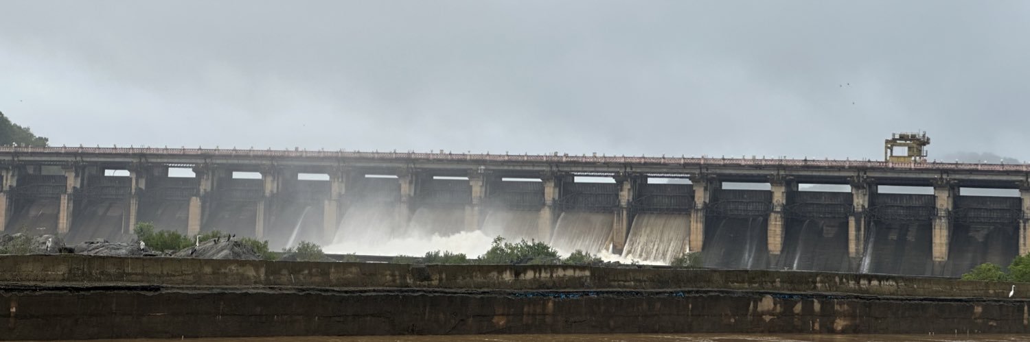
Dindi Dam Aerial view of flooding yesterday. #CycloneMontha Video Credits to respective owner.
Naveen Reddy139,294 Aufrufe • vor 8 Monaten

Allagadda - Ahobilam Road, Nandyala district of AP. Continuous rain over the past week has washed away the maize. When I was there last week, farmers along the 25 km stretch from Allagadda to Ahobilam were drying their harvested maize on the road. I don’t think the crop is usable or sellable anymore. #CycloneMontha
Naveen Reddy130,000 Aufrufe • vor 8 Monaten

This is so soothing to watch. Perur Dam is now receiving its first flood inflows through the Penna River following heavy rainfall in the Sathya Sai district and Karnataka's Tumakuru district. It's wonderful news for the entire region. After four years of uncertainty, there is renewed hope that the dam could finally reach its full capacity this year if the monsoon continues to perform well.
Naveen Reddy30,960 Aufrufe • vor 1 Monat


Krishna River has run completely dry in parts of Belagavi district, North Karnataka. The Western Ghats across Karnataka and Maharashtra are still struggling to receive normal monsoon rainfall, and the effects of El Niño are becoming painfully evident. Forwarded video.
Naveen Reddy14,792 Aufrufe • vor 22 Tagen

Ichari Dam located on the Tons River, a major tributary of the Yamuna River near Khodri, in Dehradun District, Uttarakhand. Origins at Bandarpunch glacier, Tons is actually longer and carries more water than the Yamuna at their confluence. Some geologists believe that it may have once been the original course of the Yamuna. Merges with the Yamuna River near Kalsi, Dehradun district. 🎥Riyadh Ali.
Naveen Reddy132,529 Aufrufe • vor 10 Monaten


A man is stranded on an electric pole in the flooded Tons River near Sudhowala, Dehradun. Rescue operations are currently underway. Tons River is the largest tributary of the Yamuna River. Origins from the Bandarpunch Mountain/glacier in the Garhwal Himalayas, Joins the Yamuna near Kalsi, in Dehradun district. 🎥Kapil
Naveen Reddy91,621 Aufrufe • vor 10 Monaten