
Nick Bender
@NickBenderKMBC • 21,165 subscribers
Morning & Noon Meteorologist & Storm Chaser at @KMBC in Kansas City. I call the Plains Home. Christian. Husband. Father. Penn Stater. Angler. #MOwx #KSwx
Shorts


Videos
🌪️ May 28, 2019. I think about this day often each spring. A mile-wide EF-4 tornado, with estimated peak winds of 170 mph, cut a 32-mile path across Douglas and Leavenworth counties in Kansas. We tracked this mostly rain-wrapped violent tornado from a safe distance along K-10 in StormTracker9 as it approached the western side of the Kansas City metro. The tornado dissipated near Bonner Springs, KS, but the parent supercell thunderstorm cycled and produced a separate EF-2 tornado near Kearney, MO. Miraculously, there were no fatalities, but 18 people were injured, and numerous homes and businesses were heavily damaged or destroyed. What do you remember from this day?
Nick Bender18,693 просмотров • 1 месяц назад

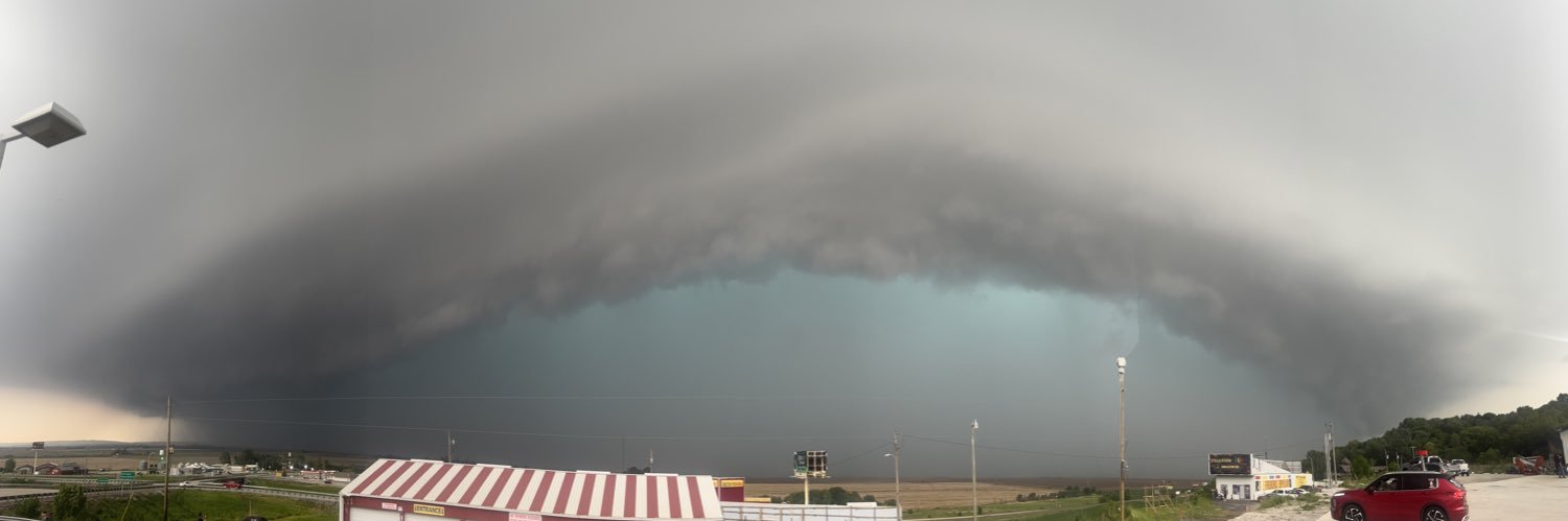
$100,000,000 hail disaster in Kansas City? It’s possible after two supercell thunderstorms pummeled parts of western and northern Kansas City with hail up to 4.5 inches in diameter—that’s grapefruit-sized. Residents, business owners, insurance adjusters, and roofers have some long days and weeks ahead. Video from Angela in northern Kansas City on March 10, 2026.
Nick Bender37,964 просмотров • 4 месяцев назад


❗️Destructive straight-line winds, golf ball- to baseball-sized hail, tornadoes, and school districts letting out early. Some of you may be experiencing storm anxiety and fatigue ahead of today’s severe weather risk, especially after the events of this week. Here’s a short video to watch that will hopefully help calm some of those fears and help you prepare. Posted Friday, April 17, 2026. KMBC
Nick Bender21,202 просмотров • 3 месяцев назад

⌚⚡ Individual supercells are possible ahead of the dryline tomorrow between 4 PM and 7 PM across southeastern Nebraska and northeastern Kansas. Thunderstorms are expected to grow upscale into a line or clusters and move eastward into eastern Kansas and northwestern Missouri between 7 PM and midnight, arriving around 9 PM to 11 PM in the Kansas City metro. Storms will continue moving eastward across Highway 65 in northern and central Missouri after midnight through 2 AM Friday. ☄️🌪️💨 Thunderstorms that initially develop off the dryline and remain individual or discrete could produce very large hail, damaging wind gusts, and a tornado or two. 💨🌪️ As storms grow upscale into a line or clusters after sunset, damaging wind will become the primary threat, with the potential for a brief tornado. 🖥️ Here’s the latest run of Futurescan showing the potential evolution of thunderstorms from late afternoon into Thursday night. It may not be 100% accurate, but I think it’s doing a good job of handling the location, timing, and evolution.
Nick Bender16,584 просмотров • 2 месяцев назад


🌊Flash flooding is occurring across the Kansas City metro! As of 4:50 AM on 7/17/2025, numerous high-water rescues are taking place. Observed and radar-estimated rainfall amounts between 6'' and 10'' have already fallen, with additional rainfall amounts of up to 2'' expected. PLEASE remain vigilant if you live near a stream or creek, and use extreme caution when driving this morning, especially before sunrise. Remember the motto to keep you safe: "Turn around, don't drown!" This video is from Brush Creek on the Plaza. #MOwx #KSwx KMBC
Nick Bender49,397 просмотров • 1 год назад

🌪️ Tornado Warning Atchison, MO. In Rock Port, MO. Massive HP supercell. Time 4:50 PM. KMBC NWS Kansas City
Nick Bender12,518 просмотров • 2 месяцев назад


❄️ Here are some of my thoughts before bed on when the Winter Storm Watch may expand to include Kansas City, whether it’ll be upgraded to a Winter Storm Warning, the (crazy) snowfall amounts, and the potential for school closings. Give it a watch and share! Video posted Wednesday, January 21, 2026. KMBC
Nick Bender18,279 просмотров • 5 месяцев назад

❄️🚫 No cold, no snow—just a lot of rain! Widespread rain will spread northward toward I-70 and Kansas City early Saturday morning. By noon, an enveloping swath of rain will reach as far north as Highway 36 in northern Missouri near St. Joseph, Cameron, and Chillicothe. Rain will continue through the afternoon before tapering off from west to east Saturday evening. Temperatures will hold in the 40s and 50s Saturday morning and afternoon, ensuring all precipitation falls as rain, with no wintry mix expected. Rainfall amounts will range from 0.10 to 0.25 inches near and north of Highway 36 in northern Missouri, 0.50 to 1.00 inch near I-70 (including Kansas City), and up to 1.5 inches south of I-70 near Garnett, Pleasanton, Butler, Clinton, and Warsaw.
Nick Bender15,595 просмотров • 5 месяцев назад

❄️ ❗️ Heavy snow amounts are starting to lock in, but there are still some failure modes. Here’s what I’ll be looking for to receive 6 to 10 inches of snow in Kansas City. Give it a watch! Please share so everyone can prepare. Posted Thursday, January 22, 2026.
Nick Bender16,739 просмотров • 5 месяцев назад

🚫 There is more than one day schools may close due to dangerous cold. That’s always a difficult call to make, with so many things to consider. Parents, teachers, and staff—here are my thoughts! Please share so everyone can prepare. Posted Thursday, January 22, 2026.
Nick Bender11,994 просмотров • 5 месяцев назад

🌬❗ Dangerously cold Friday through Monday. Temperatures near 0° each morning will combine with brisk winds to produce wind chills between -5° and -25°. At the extreme of those wind chill values, frostbite can occur on exposed skin in 30 minutes or less. Once wind chills drop below 0° late Friday night, they will not rise above 0° until Sunday afternoon. Please help me prepare everyone by sharing this. Posted Thursday, January 22, 2026.
Nick Bender11,184 просмотров • 5 месяцев назад

Больше нет контента для загрузки