We just had to share this impressive imagery of... severe thunderstorms sweeping across Texas yesterday, captured by NOAA's #GOESEast (#GOES19) 🛰️. The visible imagery reveals fine details within the storms, while the satellite’s Geostationary Lightning Mapper highlights where lightning flashes occurred.show more

NOAA Satellites
49,017 次观看 • 3 个月前
Severe thunderstorms quickly advanced across the Northern U.S. Plains... over a six-hour period from June 7 to June 8—the days leading up to this #TimeLapseTuesday. The Geostationary Lightning Mapper aboard NOAA’s #GOESEast (#GOES19) 🛰️ gives us an idea of just how much lightning the Plains saw during these storms.show more
NOAA Satellites
10,999 次观看 • 2 个月前
This imagery from NOAA's #GOESEast 🛰️ is providing visible... cloud imagery every 30 seconds of #HurricaneMilton as it pushes closer to Florida. Notice the frequent #lightning being picked up by the satellite's #GLM instrument as well. Get the latest on #Milton:show more
NOAA Satellites
1,518,604 次观看 • 1 年前
This #FullDiskFriday, we’re showcasing Earth’s land surface temperatures (LSTs)... captured by NOAA's #GOESEast (#GOES19) 🛰️ following a week of extreme heat. GOES-19 used infrared observations to measure LST, but clouds can block its view of the surface. Areas shown in gray indicate where temperature data was unavailable.show more
NOAA Satellites
11,475 次观看 • 12 天前
THIS IS NOT A GLITCH. THIS IS ELECTRICITY ABOVE... THE CLOUDS. High above the most violent thunderstorms on Earth, something almost impossible flickers into existence... jellyfish-shaped bursts of red light dancing at the edge of space. They're called Red Sprites. These ghostly flashes erupt 30-50 miles above active storms, triggered by the massive electrical discharge of a lightning massive electrical discharge of a lightning bolt below. While the bolt strikes downward toward the ground, sprites fire silently upward toward space. The insane part? SO They vanish in under 10 milliseconds fast the human eye can barely register them which is why most people have never seen one despite storms happening every second somewhere on Earth. Storm chasers chased them for years without proof. Scientists finally confirmed they were real in 1989. 4 When you see one, you're watching electricity escape Earth's atmosphere entirely. Have you ever caught a glimpse of a Red Sprite? Upper atmosphere, 30-50 miles above thunderstorms. ▲ Visual may be enhanced to illustrate the phenomenonshow more

Physics & Astronomy Zone
31,910 次观看 • 5 个月前
LEVEL 2 SEVERE WEATHER ALERT DAY TODAY ⚠️⛈️ As... expected, the SPC has placed most of the PIX11 News viewing area under a LEVEL 2 severe weather risk for damaging winds, dangerous cloud-to-ground lightning, torrential rainfall, and hail. The primary severe threat appears to be strong to damaging wind gusts and small hail, while the tornado threat remains low. A few storms could develop earlier this afternoon across the Lower Hudson Valley, NW New Jersey, Lehigh Valley, and the Poconos before a more organized line moves through late this evening. On PIX11 News at 9am with the latest timing and impacts.show more

Mike Masco
22,811 次观看 • 3 个月前
From International Space Station, we have a unique vantage... point to observe lightning storms from directly above them. Much like from the ground, they appear as rapid, intense flashes that are over as quickly as they started. But, with the help of handheld cameras and a bit of practice (and, admittedly, some luck), we can capture these intense flashes with a very high frame rate then slow them down to see how the lightning propagates. It's lightning, in slow motion. This is one that occurred over Indonesia on 6/28. I shot it for a half second at 1/120 frame rate, so, 60 separate frames. I then compiled those frames into two videos: the first, in real-time, and the second, slowed down so that each frame is a half second to highlight the progression of the flash. Note the incredible burst of light in one frame, which includes what is likely a TLE on the upper left. A TLE, or Transient Luminous Event, is an electrical discharge that happens in the upper atmosphere above lightning storms (if you haven’t seen Ferry Farhan TLE photo from last week, head over to her page). As their name implies, these are transient, or short lived, phenomena – it appeared in only one frame of the sequence, lasting for no more than 1/120th of a second. The last photo is that single frame. Absolutely incredible.show more

COL Anne McClain
82,113 次观看 • 1 年前
Earth runs on an electromagnetic heartbeat that has been... circling this planet since before the first human being stopped to take a breath while admiring the beauty. At any given moment about 2,000 thunderstorms roll across Earth, producing over 50 flashes of lightning every single second. Each lightning burst creates electromagnetic waves that begin to circle around Earth captured between Earth's surface and a boundary about 60 miles up. Each burst launches electromagnetic waves that wrap around the planet, trapped between the surface and the ionosphere some 60 miles up. When the wavelength lines up just right with the circumference of Earth itself, those waves stop competing and start amplifying each other to create a repeating atmospheric electromagnetic heartbeat known as Schumann resonance. Research suggests our cells evolved to resonate with this frequency as our brain does produce electrical rhythms that harmonize with it. That harmony is linked to our cellular function and even consciousness itself to regulate your circadian rhythm, mood, cognitive function, melatonin production, heart rhythm and overall vitality. We’re literally wirelessly bluetoothed to Earth’s electromagnetic field. Earth has a frequency and it always has. Why aren't we taught about this in school and who benefits the most from keeping it a secret?show more

Bridgett Fertig
12,508 次观看 • 2 个月前
🇺🇦🇷🇺As Ukraine's asymmetric strike capabilities continue to force a... radical shift in maritime defense, naval assets anchored deep within rear infrastructure are adopting improvised structural modifications to mitigate the persistent threat of aerial and surface drone strikes. 🇷🇺 The Russians have begun installing anti-drone nets (cages) on the Black Sea Fleet submarines stationed in Novorossiysk 🛰️ Satellite imagery reveals that metal structures are being mounted on 3 Varshavyanka-class submarines. Another one is reportedly being prepared for similar "armoring." ▪️ The reason cited is the growing threat from Ukrainian unmanned aerial vehicles. They are attempting to provide additional protection for the submarines against expected attacks from the air and sea, even while they are docked in port. Video is generated by Grok AIshow more
NSTRIKE
19,999 次观看 • 2 个月前
Details shared by Vinay from Kurnool, Andhra Pradesh -... Yesterday morning I was travelling from Kurnool (Andhra Pradesh) to Gulbarga (Karnataka). I had pulled my Nexon over to the side of the road for a tea break and was moving slowly along the shoulder when a lorry came from behind and hit me. When I confronted the lorry driver, he claimed he hadn’t even touched, But my dash-cam had captured everything. After we reviewed the footage, he apologised. Even so, I refused to let him leave until the police arrived, because in his drunken state he could have caused another accident. He had been driving all night without rest while intoxicated. The police arrived and took both the lorry and the driver into custody. The incident occurred on the Hatti–Gudur Bhaba stretch of the Raichur-to-Gulbarga road.show more

Prateek Singh
294,104 次观看 • 1 年前
Last night, death visited our building. None of us... knew. At 1:40 a.m., a violent explosion tore us from our sleep. The blast ripped through the plastic sheeting covering our windows. The glass had been shattered long ago by previous airstrikes. Within seconds, windows flew open across the neighborhood. Faces emerged from the darkness as phone flashlights swept over the street like tiny stars trying to replace a sky that had abandoned us. Even the moon seemed to hide behind the clouds, unwilling to witness what had happened. We knew death had arrived. We just didn’t know whose door it had chosen. Some neighbors went downstairs. We stayed where we were, caught between the instinct to run and the fear of becoming the next target. Minutes later, ambulances arrived. They moved slowly through the streets before the paramedics stepped out and asked, “Where was the strike?” No one knew. The darkness had swallowed everything. After searching for nearly fifteen minutes, they drove away. We assumed they had found the victims. The next day, around noon, we learned the truth. The apartment that had been struck was in the very building where we are renting our home. A husband and wife had been killed just a few meters from us. All night, we searched for death with the light from our phones, never realizing it had already climbed the same staircase we use every day. Even the ambulances had stopped beneath our building without realizing the place they were searching for was directly above them. Over the past few days, the Israeli military has intensified its attacks across Gaza. Walking to work is dangerous. Standing in the street is dangerous. Returning home has become an act of hope rather than certainty. This is how we live now. Death no longer knocks. It slips silently through the darkness, chooses an apartment, and disappears before anyone understands where it has been. By morning, the world is already reading another headline. But we remain here, living in buildings where even the moon seems too frightened to look through our windows, wondering every night whether tomorrow still belongs to us. #WoundedGazashow more

Dr. Ezzideen
13,833 次观看 • 1 个月前
So, we all know that the birth of Jesus... was announced by a star in the East, a special star that rose before the Sun, and that three Magi, or Babylonian astrologers, came bearing gifts for the birth of Jesus. But what was this star? Ancient astrologers followed the movements of the planets, the Sun and the Moon in relation to the zodiac constellations. I found a specific and extremely rare conjunction of Venus and Jupiter, the two brightest planets visible in our sky, in the constellation of Leo. To make the connection even stronger, Jesus is called the Lion of Judah! Conjunctions of Jupiter and Venus occur almost every year, but what made this conjunction so special and rare was that the planets came extremely close, within less than 0.01°, and appeared as one very bright star in the morning sky, as seen from the Levant and ancient Persia. This alignment occurred in 2 BCE. To make it even more interesting, Jesus would have been exactly 33 years old in March AD 33, when the solar eclipse occurred in Pisces. Exactly 2,000 years later, in 2033, we will witness the same solar eclipse in Pisces. You cannot make this up. It is all there. The signs in the stars do not lie. Venus and Jupiter are associated with the divine masculine and feminine energies. Venus is also close by in the same sign during both eclipses. The eclipse in AD 33 was visible from, or had its greatest influence on, the South Pole, while the eclipse in 2033 will be visible from the North Pole, once again representing the opposite forces of the planet.show more

Open Minded Approach
55,359 次观看 • 14 天前
Tuesday, April 14, 2026 at 6:52 AM: What you... have witnessed yesterday and this past weekend across California and parts of Southern California is the birth pains of an El Niño development and the ongoing escalation the warming of the Pacific torrential rains came through the San Fernando Valley with such strong, thunderstorms that it caused significant flooding in the Sherman Oaks, Universal City area around 1:05 PM - 1:35 PM yesterday on April 13, 2026. This powerful storm packed winds gusts of over 50 mph and it’s a true testament that we are no longer in a pattern that brings rain in just winter time but is now extending into April and May and beyond with that said we have another storm on the heels that will be arriving very quickly on April 21 - 27, 2026. The next storm will also bring more heavy rain, thunder, and lightning, and yes, more snowfall to the local mountains. As the Pacific continues to warm, the weather will become more drastic with extreme heat waves and more unusual severe rain events for California. This situation will get quite scary if it continues to verify by the end of October and November with the super El Niño development and the atmosphere connecting something that we’ve not seen since 1982, 1997/ 1998. The main Marshall Islands low axis is already gearing up for this major event this year which you’ve seen an example already. The flooding in the Hawaiian islands. Typhoon Sinlaku has now hit the Guam region with a category five status this early in April all due to the warming of the Pacific and the emergence of El Niño. #CAwxshow more

Jason D Farhang
28,670 次观看 • 4 个月前
Today, we visited the Minab school in southern Iran,... where US forces massacred 168 students and teachers at the outset of the Trump-Netanyahu war of aggression on Iran. About ten minutes after we left the Minab school today, it was hit with a drone strike. (The aftermath of that strike was captured in this video). Yesterday, we were in the Iranian city of Bushehr, which lies on the Persian Gulf to the north of Minab. Shortly after we left our hotel in Bushehr, there was an airstrike on a target directly across the street from our hotel. While we were in Bushehr, we visited a marine terminal that had sustained damage in airstrikes conducted earlier this month. Shortly after we left the marine terminal, it too was hit with an airstrike. Another site that we visited in Bushehr yesterday was also hit with an airstrike shortly after we left it. Now all of this could be random. On the other hand, it may be that U.S.-Israeli forces are sending us a message. If in fact they are sending us a message, we have a message for them. Our message is that no amount of intimidation will stop us from exposing their monstrous crimes. #Iran #Iranwarshow more

Dimitri Lascaris
442,998 次观看 • 5 个月前
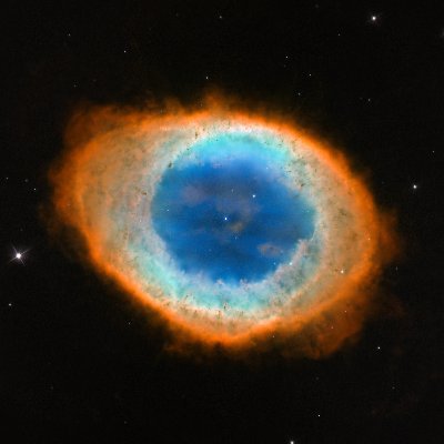
On March 6, 2015, astronomers reported observing a supernova... in a distant spiral galaxy. Although the explosion itself occurred millions of years earlier, the light carrying that event had only just reached Earth after traveling across intergalactic space. This delay is not unusual but a fundamental feature of the universe, where distance and the finite speed of light turn every observation into a glimpse of the past. In this way, telescopes function not just as instruments of sight, but as time machines, revealing events long after they have concluded. Each distant supernova reminds us that the cosmos we observe is a layered history, unfolding to us not as it is now, but as it once was across unimaginable spans of space and time. Credit: NASA/ESA Hubble Space Telescopeshow more
Cosmos Archive
23,079 次观看 • 4 个月前
Major Storm to Impact Southern California As of Wednesday,... February 12, 2025, at 6:50 PM PDT, the latest infrared satellite imagery confirms that the incoming storm system is fully developed and on track to deliver severe weather across Northern and Central California tonight into early Thursday afternoon. The system is intensifying rapidly, with a powerful surface cold front expected to sweep through San Luis Obispo to San Diego counties, bringing damaging winds, torrential rainfall, and the potential for severe thunderstorms. Key Storm Impacts: "Big Thursday" – A Major Weather Event • Extreme Rainfall Rates – 0.50 to 1.5 inches per hour, increasing the risk of urban flooding, flash floods, and mudslides, particularly in burn scar areas of Los Angeles County. • Damaging Winds – Southerly gusts of 45-65 mph, capable of toppling trees, damaging weak structures, and causing widespread power outages. • Severe Thunderstorm & Weak Tornado Potential – The latest HRRR model data (18Z, 0Z) indicates the presence of a squall line, increasing the risk of isolated severe thunderstorms and weak tornadoes between 12 PM and 10 PM Thursday. • Scattered to Widespread power Outages – Areas at risk include the San Fernando Valley, Santa Clarita Valley, Ventura County, and portions of Los Angeles County, where infrastructure could be severely impacted. • Urban Flooding Concerns – Locations such as Downtown Los Angeles, Pasadena, Altadena, and Pacific Palisades will experience rapid runoff and potential roadway flooding, creating hazardous travel conditions. The Seriousness of the Situation This storm is shaping up to be one of the most intense weather events of the season, posing a significant threat to life and property. Residents in Los Angeles County and surrounding areas must prepare for prolonged heavy rainfall, high winds, possible power outages, and dangerous road conditions. Authorities urge residents to stay indoors, avoid unnecessary travel, and prepare emergency supplies. Those in flood-prone and burn scar areas should be especially vigilant for potential debris flows and flash flooding. This is a rapidly evolving situation and further updates in the next 24 to 30 hours. #CAwx #CaliforniaStormsshow more
Jason D Farhang
30,044 次观看 • 1 年前