Загрузка видео...

Не удалось загрузить видео

На главную

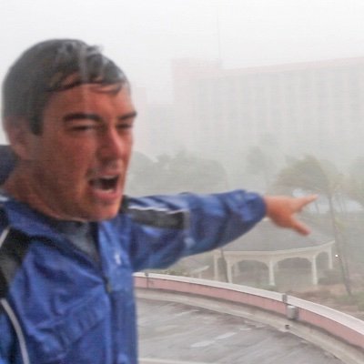
Hurricane #Idalia’s outerbands with embedded thunderstorms spiraling over Gainesville, Florida. Idalia’s eye should make landfall on the coast around sunrise tomorrow morning. This will be my 65th Tropical Cyclone intercept since 1987 !!
101,992 просмотров • 2 лет назад •via X (Twitter)

Комментарии: 0

Нет доступных комментариев

Здесь появятся комментарии из оригинального поста

Похожие видео

Y'all see this swirl over the Mediterranean passing south of Benghazi? That's not a hurricane – it's a Medicane. Yes, that's a real term. The word is a portmanteau combining "Mediterranean" and "hurricane." The Mediterranean is too small to support barotropic (tropical cyclones) the scale of conventional hurricanes AND is too far north to support a truly tropical cyclone anyway. Moreover, water temperatures are too cool. (Most tropical cyclones exist over sea surface temperatures of 78 degrees or warmer; the current water temperature off the coast of Libya is about 63 degrees.) Medicanes can and occasionally do reach hurricane strength. The strongest on record was Medicane Ianos, which impacted Greece between September 17-18, 2020. It briefly became the equivalent of a tiny Category 2 hurricane with winds of 95 mph. On rare occasions, a nontropical low can meander over the Mediterranean, and a storm can form that takes on some tropical characteristics. Unlike nontropical cyclones, which are common at the mid-latitudes, medicanes feature a warm core. That requires warm sea surface temperatures. A 2016 study found that medicanes are likely to become significantly stronger by the end of the century in response to warming sea surface temperatures. Tthe researchers found a likelihood for "a higher number of moderate and violent medicanes.” Since 1980, Mediterranean sea surface temperatures have increased between 1 and 2 degrees.

MyRadar Weather

36,923 просмотров • 4 месяцев назад

Wednesday, April 3, 2024, 5:42 PM PDT: All systems are a go for a cold and unseasonable Gulf of Alaskan April storm. Strong thunderstorms have already developed near Redding, California, and a series of embedded impulses are rotating around the main low axis off the coast of Humboldt County this afternoon. This storm system will undergo a brief 12 to 24-hour intensification process before hitting San Francisco, Santa Rosa, and Sacramento late Thursday afternoon. It will bring isolated strong to severe thunderstorm conditions. A large surface cold front will develop late Friday morning as the low axis trajectory slides down the coast towards Pismo Beach, California by Friday at dawn. Severe Weather Risk In Central And Southern California on Friday. The atmospheric conditions will become increasingly unstable, giving way to thunderstorms from central California to San Diego. The cold pool of air aloft, at minus 28 Celsius above 25,000FT, will create volatile weather conditions with the possibility of pea-sized hail and brief heavy rainfall in some areas. The air mass will be very cold, supporting a dusting of snow near the Grapevine and Cajon Pass. Temperatures will drop into the 40s and 50s, and the 30s near the mountains by Friday midday. As snow levels have been trending downward and hit rock bottom, there may be some isolated areas at 2,000-foot elevation along the San Gabriel’s and parts of the San Bernardino mountains that could see a dusting of snow. Even some dusting of snow in the high desert cannot be ruled out. There is a high confidence of elevated water spouts developing from San Luis Obispo to San Diego coastal zones, especially since one of the embedded disturbances will arrive on Friday from 11 AM to 7 PM. This is also the best opportunity for ample early April sun angle, which will give way to stronger convection across our region. I'm closely monitoring this developing situation in the next 24 hours. #Californiastorms #ElNiño #April2024

Jason D Farhang

23,214 просмотров • 2 лет назад