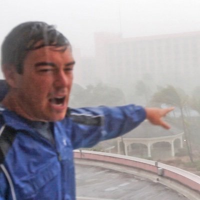
Hurricane #Idalia’s outerbands with embedded thunderstorms spiraling over Gainesville,... Florida. Idalia’s eye should make landfall on the coast around sunrise tomorrow morning. This will be my 65th Tropical Cyclone intercept since 1987 !!show more
Mike Theiss
102,015 views • 3 years ago
Extremely Severe Cyclone Mocha is expected to make landfall... around the Bangladesh-Myanmar coast tomorrow morning. Strong winds, heavy rain and storm surge will be hitting vulnerable communities, likely to bring devastating consequences. | Simonshow more

BBC Weather
60,159 views • 3 years ago
The calm before the storm in Florida. A gorgeous... sunset tonight ahead of Category 5 Hurricane Milton with evacuation traffic heading north. I’ll be in Tampa area tonight and documenting Milton throughout landfall Thursday morning. Keep an eye on my page to see updates about Milton from on the ground 🌀 #milton #flwx #hurricaneshow more

Dan Whittaker
88,960 views • 2 years ago
🌀TROPICAL CYCLONE ALFRED NEARS QUEENSLAND 🇦🇺 🌏Tropical Cyclone #Alfred,... currently a Category 2 storm, is approaching Queensland, Australia, with landfall expected early Friday morning between the Sunshine Coast and Gold Coast, possibly impacting Brisbane. ⚠️ Winds near the center reach 85 km/h, with gusts up to 120 km/h. It may intensify to ⚠️Category 3 before landfall. 🌀 The cyclone is expected to bring storm surges up to 1 meter, damaging winds up to 130 km/h, and heavy rainfall of 200-400 mm daily, with totals exceeding 800 mm, posing a significant flood risk. 🇦🇺 Bureau of Meteorology, Queensland has issued evacuation notices for coastal areas. Schools and public transport will shut down starting Thursday. Nearly 20,000 properties in Brisbane could be impacted by flooding.show more

Windy.com
23,825 views • 1 year ago
The previously unnamed Tropical Storm in the shallow Malacca... Strait has since been given the name Senyar. The system made landfall over the city of Langsa in Aceh, Indonesia at a 50 mph (80 kph), 996 mbar peak intensity. But Senyar isn’t done. The storm has now RE-EMERGED into the Malacca Strait and is forecast to soon make a second landfall, this one in Malaysia. While Senyar won’t be very strong (potentially only ~40 mph), a Malaysian landfall by a bonafide tropical cyclone is historically rare, as few storms on record have formed this close to the equator (due to the weakness of the Coriolis Effect here).show more

Backpirch Weather
314,804 views • 10 months ago
⛈️ Heavy rainfall and flooding threat from South Texas... to the lower Mississippi Valley A multi-day episode of heavy rain will be driven by the interaction of a nearly stationary cold front, tropical moisture, and a tropical disturbance. The tropical disturbance is currently located over Mexico and will gradually move toward South Texas. According to the NHC/NOAA, the chance that it will organize into a tropical cyclone remains low, around 30%. Regardless of whether a tropical cyclone actually forms, the system may bring intense showers and thunderstorms along the western and central Gulf Coast. Over the next four days, widespread rainfall totals of 4 to 6 inches are expected from the Texas coast into Louisiana, with locally higher amounts possible. Such rainfall totals could trigger flash and river flooding, posing a significant threat to life and property. ⚠️ Please monitor official warnings and follow the instructions of local authorities.show more
Windy.com
11,854 views • 3 months ago
Extreme Atmospheric Dance 🕺 Watch how a record shattering... September Heat Dome across the US East, helps spawn a strong upper level low over #Florida this weekend trapped south of the dome. Under the heat dome hundreds of heat records will be broken, with heat index numbers up to 110. In Florida the upper level low may help cause some severe thunderstorms with hail this weekend. This is NOT a tropical system. #heatwaveshow more

Jeff Berardelli
56,264 views • 23 days ago
TROPICAL UPDATE: Invest #97L odds haven't changed the past... 12 hours, still at 70%. I feel the NHC wants to wait until the Hurricane Hunters get a better look at it this thing under the hood. Considering this will be pushing onshore *tomorrow* in TX/LA, I still would have preferred Potential Tropical Cyclone/System to be designated so more tropical weather alerts and communication products could have been issued. For example, my sister is a teacher in the Galveston Bay area. She is under the impression she is going to school Tuesday (along with her kids) because a Tropical Storm Watch/Warning has not been issued yet. The school district needs that additional information to make better decisions. I have a lot of respect for the NHC, I just disagree with them on this one.show more

Matt Devitt
35,325 views • 1 month ago
I am almost sure that #Tampa, #Florida will be... spared the worst of #hurricane #Milton and it appears very likely the storm may make landfall and a direct hit on #FortMyers. For most of the night Milton has been hugging the lowest level on National Hurricane Center's projected path (cone) or has wandered south of it a few times. Since then it has been pretty much following the lowest point of the cone right into Fort Myers. There is still a possibility it may track slightly south of there, just north of #Naples.show more

Jason Safoutin
139,923 views • 2 years ago
Moist Conveyer Belt Builds over Florida! And a big... shift too. The models are coming into much better agreement on a significant, but not deluge, rain event for West-Central Florida this weekend through next week. Heaviest totals will be along the coast. Emphasis “coast”. Expect on and off downpours - not always a washout - with the worst weather Sunday & Monday. Models show a widespread 2-4” Sanibel to Tampa to Crystal River to Panama City, but obviously with tropical bands/ downpours some spots will see much more with some localized flooding too. *BUT there’s been a noticeable shift “West” into the #Gulf next week with the moisture blob pulling away. So the spigot shuts down more quickly from Tampa southward by Tuesday. #florida #stormshow more
Jeff Berardelli
32,095 views • 2 months ago
As Tropical Storm Bertha’s almost nonexistent center moves through... Louisiana, an intense, convective lightning storm in association with her broader circulation is now crackling above the Houston skyline. SE Texas will soon host the final landfall location for Bertha once she swims out of the swamp and back into the Gulf, and this is where any freshwater flooding risk should be greatest tonight and tomorrow. Thus far, besides some coastal tidal surge in the Florida panhandle and Mississippi, Bertha’s impacts have fortunately been minimal thanks to strong wind shear.show more
Backpirch Weather
13,426 views • 2 months ago
Y'all see this swirl over the Mediterranean passing south... of Benghazi? That's not a hurricane – it's a Medicane. Yes, that's a real term. The word is a portmanteau combining "Mediterranean" and "hurricane." The Mediterranean is too small to support barotropic (tropical cyclones) the scale of conventional hurricanes AND is too far north to support a truly tropical cyclone anyway. Moreover, water temperatures are too cool. (Most tropical cyclones exist over sea surface temperatures of 78 degrees or warmer; the current water temperature off the coast of Libya is about 63 degrees.) Medicanes can and occasionally do reach hurricane strength. The strongest on record was Medicane Ianos, which impacted Greece between September 17-18, 2020. It briefly became the equivalent of a tiny Category 2 hurricane with winds of 95 mph. On rare occasions, a nontropical low can meander over the Mediterranean, and a storm can form that takes on some tropical characteristics. Unlike nontropical cyclones, which are common at the mid-latitudes, medicanes feature a warm core. That requires warm sea surface temperatures. A 2016 study found that medicanes are likely to become significantly stronger by the end of the century in response to warming sea surface temperatures. Tthe researchers found a likelihood for "a higher number of moderate and violent medicanes.” Since 1980, Mediterranean sea surface temperatures have increased between 1 and 2 degrees.show more

MyRadar Weather
36,923 views • 6 months ago
This darn storm man... back for more intensification now... over the waters between Jamaica and Cuba. The eye has rapidly reformed this evening, with significant lightning in the western side -- that is indicative of fast intensifying hurricanes. Santiago de Cuba is Cuba's 2nd most populated city and could take hurricane conditions overnight. Only three major hurricanes have ever tracked across eastern Cuba in history: Matthew (2016), Ike (2008), Dennis (2005) Melissa will become the fourth overnight into Wednesday morning. Should be a pretty solid storm surge into Guantanamo Bay even away from the eye.show more

Noah Bergren
311,220 views • 11 months ago
One thing we are watching now is potential ERC... (eyewall replacement cycle) beginning. Pressure / wind may have temporarily peaked. Some of the hurricane models have suggested multiple eyewall replacement cycles through Tuesday. For tonight, it is possible this eyewall replacement is quick then we see another dip even stronger overnight with lower pressure and even higher winds. These eyewall replacement cycles will have impacts on how the storm comes into FL Wednesday night. Eventually these should grow the eye and core with time. If the cycles are finished before it hits the wind shear, that could make it a little more resilient to the wind shear. A smaller eye and core probably gets bothered more by the dry air intrusion/wind shear that should be meeting up with #Milton late Wednesday off the Tampa coast. So, these cycles are important in the eventual core structure as it nears the coast late WED.show more

Noah Bergren
111,635 views • 2 years ago
‼️I don't think people are grasping how MISERABLE this... Winter Storm will be. This Winter Storm will be NOTHING like last week’s storm❌ 🥶 Portions of the Carolinas will turn into SIBERIA on Saturday, as Hurricane Force Wind gusts and close to a FOOT of Snow fall at the same time. 🌀 Our Storm is what’s called a BOMB CYCLONE, meaning it is a rapidly strengthening Low Pressure System. 💨 Instead of a calm, steady Snow, conditions will be ABSOLUTELY BRUTAL inside the core of the storm as Blizzard like Snow and Wind WHIP around. 🌡️ On top of that, Temperatures will be Frigid, with Wind Chills close to 0. I’ll have another update later tonight, but right now this is looking like a BIG ONE for our Carolina brotheren. More to come my brotheren. 👊❄️show more

Brady Harris
336,061 views • 8 months ago
We have an unusually High #Tornado Threat from #Hurricane... Isaias This movie uses real data, to help educate on why this storm poses an enhanced risk. Notice the yellow vs blue arrows. Yellow are the winds just below the clouds, it’s the low level wind flow (jet) around and feeding into the storm. Blue are the mid-level winds associated with the jet stream. You’ll notice that as Isaias approaches the Gulf Coast the blue arrows increase and the low-level vs mid-levels winds vigorously cross (X) each other. That’s the jet stream (blue arrows) being infused into the tropical system. That will create more cross winds/ shear, weaken #Isaias, but embolden spin in the outer bands. This injection of energy will power strong #tornadoes on the storm’s east side at landfall in the #Florida Panhandle and beyond into the Southeast. Not all storms have this, but it’s more common in fall as the mid-latitude jet stream increases. And it gives the transitioning tropical storm system a different character. It causes the wind field at the core to expand, making the storm larger, empowering the outer bands with more wind, at the expense of the core winds which weaken. (Although all set ups are different, Milton and Sandy come to mind) *This animation does use real wind data, but the tornadoes are added to illustrate where the greatest risk is. They are not meant to forecast exactly where the tornadoes will be.show more
Jeff Berardelli
74,350 views • 1 day ago
Gulf Tropical Development? Hmmmm maybe. Models are 50/50. It... is possible, but the window of opportunity is narrow in time and space. To be clear: I certainly think a system may form, but I am skeptical of a strong system. Still am. Let’s discuss why. That’s because wind shear is generally overwhelming, with one small exception over the Central and SW #Gulf. In about a week a short window will open where there will be a corridor of low wind shear, just favorable enough for development- most likely in the S-Central Gulf or SW Gulf / Bay of Campeche. BUT the “bubble” where this can organize and strengthen is tight. So it will face uphill odds thanks to #ElNino strong shear. Still, you never know for certain, sometimes divergence aloft ahead of the strong shear can enhance, so there’s an off chance it over performs. I’ll keep you updated. Perhaps more importantly, with tons of Gulf moisture, the Gulf Coast & #Florida should be ready for an extended period of enhanced rain. #hurricane #hurricaneseasonshow more
Jeff Berardelli
16,104 views • 8 days ago
Omo… how do I convince Blueprints to concentrate on... Bluethopia alone, shebi Bluethopia should be their focus and nothing more. God help me with the knowledge on how to bring this family back to base and be more focused. Abi make I kpai myself so they’ll know handler is serious? Make I go prepare my will, who will I give my phone and 10m to?😩 #Bluethopia #BBNaijashow more

Bluethopia 💙
16,249 views • 1 month ago
Only comment on this Non-Tropical vs Sub-Tropical vs Tropical... debate for the Nor'easter, but I don't know of many purely Non-Tropical systems over 25-26C SSTs that generate their own convection by dynamics of a well structured LLC and warm SSTs. I'm not saying the system is tropical, but it's clearly acquiring some Sub-Tropical characteristics and it's broadly ignored. By the agency who should be giving this more evaluation than it is... Let's also not pretend that we haven't seen dozens of these Non-Tropical to Sub-Tropical transitions marked well away from land over the years as at least having the potential to transition, if not fully having done so. That's the continued issue. The goal posts are always moving for systems like these, and for some reason it's the storms that make US impact that tend to have less leniency in classification. Which you would think it would be the opposite. It's not November, it's September and Non-Tropical systems FREQUENTLY acquire Sub-Tropical characteristics at this latitude. Why is it only when it's actually going to impact the CONUS that we go full classroom mode and err on the side of fully NT. This goes to the same issue of not having a recon in a borderline rapidly intensifying TS Edouard earlier this month along the the most susceptible coastline in the country for our energy industry. We have more resources, more data accessibility than ever to modernize the process of tracking these systems, yet the industry still behaves like its 2000. Why isn't there a recon in this system? It will be the most impact storm for the Northeast since probably Sandy(And to be clear I'm not saying this is Sandy). IMO it's a shortcoming that does the industry no good whatsoever.show more

Garrett Bastardi
78,174 views • 13 days ago