

Jeff Berardelli
@WeatherProf • 61,778 subscribers
WFLA-TV (Tampa Bay) Chief Meteorologist and Climate Specialist. BS Atmospheric Sciences Cornell U. MA Climate Columbia U. Past CBS News NY and Miami, Tampa, WPB
Shorts


Videos


Supercharged Heat Domes are appearing all around the Planet! Why? It’s a developing super El Niño combined with a much warmer Earth, spiking natural cycles with extra heat injected into the system and pattern changes augmenting the jet stream. The US will endure one of its most expansive heatwaves in history this week. Then another long lasting record breaking heat dome will plague #Europe again, back to back on its worst #heatwave in its history! With #elnino on top of a heated globe, expect the unexpected this year!!
Jeff Berardelli469,264 Aufrufe • vor 3 Monaten

‼️ Heartbreaking video from Nepal. Villages overrun by raging flood. Hundreds of people are missing. The cause: Likely due to a Glacier Lake or dam in the mountain’s above bursting free from a snow-rock landslide, with water cascading down the hills. It took place on the Nepal-China border - that was initiated by a 4.4 Earthquake. That’s where the evidence points now, and if so, it’s called a Glacier Lake Outburst Flood (GLOF). They are more common now-a-days as glaciers continue to melt and hold more water. See image below.
Jeff Berardelli183,921 Aufrufe • vor 1 Monat

Florida will be hoarding rain over the next 2 weeks. Some spots may see over a foot! Here’s a detailed look, city by city, at what the latest European model is predicting. These totals won’t be exact, just a general idea of what to expect. One thing seems certain: some major #drought relief is coming! #florida #tropical #rain #storm #florida
Jeff Berardelli363,036 Aufrufe • vor 4 Monaten

The strongest El Niño in 150 years? Yes, it’s legitimately possible. Not hype. In fact, the “median” forecast for December of all of our computer models combined is slightly “above” the biggest event we know of back in 1877. (+2.9 vs +2.7 using ONI) While this peak intensity may or may not occur, all signs are pointing to a Super El Niño - a “natural” oscillation. That will expel stored heat from the deep Tropical Pacific - on top of significant longterm warming - heating Earth to record levels not measured before in late 2026-2027, powering extreme heat waves, droughts, and rain storms… while also suppressing Atlantic hurricane season 1/ #ElNino #extremeweather #science
Jeff Berardelli311,101 Aufrufe • vor 5 Monaten

Get ready to rock and roll! A Sudden Stratospheric Warming is on the way. In about two weeks, temperatures 12 miles up over Canada and Greenland are forecast to spike by 50°F or more. That’s a shockwave in the stratosphere — a rapid disruption of the polar vortex high above the Arctic. When the vortex gets rattled like this, it can send ripples downward through the atmosphere, reshaping the jet stream and eventually stirring up turbulent, high-impact weather patterns at the surface all around the planet. Not every SSW delivers extreme cold or storms, but events this strong often tip the atmosphere into a more chaotic setup in the weeks that follow.
Jeff Berardelli607,662 Aufrufe • vor 11 Monaten

We say #snowmageddon as a joke, but if ever there was a time to use it, it’s now!! Watch as the West Coast gets bombarded by at least 5 storms in 15 days, with up to 15 feet of snow in the high Sierra, and that may be an underestimate if the models verify. NWS says 8 feet possible by Wednesday. Incredible! #snow
Jeff Berardelli425,045 Aufrufe • vor 8 Monaten
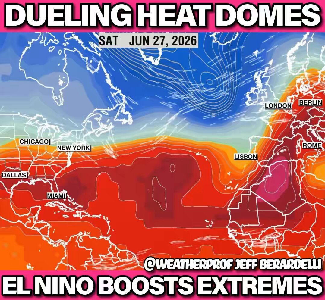
Dueling Heatwaves ‼️ Europe vs the USA in a match no one wants! It’s #Europe ’s most severe #heatwave in history with Germany highs up to 109 this weekend VS the USA where next week will be sweltering with feels like temps up to 115°! All this heat is boosted by the developing strongest El Niño we’ve ever seen, steroids on top of the heating climate! #unitedstates
Jeff Berardelli189,810 Aufrufe • vor 3 Monaten

‼️ LANDFALL 🙏 Scary situation tonight as Super Typhoon BAVI swallows the tiny Island of Rota just north of Guam. The 3D view shows how immense the 180 mph storm is compared to the islands in the path. 2000 people live there. Let’s hope they were able to protect themselves from this behemoth! 🙏 #Bavi #Typhoon #Guam #Rota
Jeff Berardelli161,540 Aufrufe • vor 3 Monaten

The biggest heat dome on the planet! Sound ⬆️ Starting now, the biggest heat dome on planet Earth will make a home here in the US, from the MS River West! It’s gonna be a brutal week with highs up to 120°+ in spots! Meanwhile in the East, it will be cooler than normal, and stormy in #Florida. #heatwave #heatdome
Jeff Berardelli131,703 Aufrufe • vor 2 Monaten

Epic snowfall in the Pacific NW!! ❄️ Over the next 10 days up to 10 feet will pile up on the higher terrain of British Columbia and Washington. Then another several feet in the 10-15 day period. And it doesn’t stop there. Oregon Montana Wyoming N Cali too! #Whistler #Blackcomb
Jeff Berardelli425,817 Aufrufe • vor 10 Monaten

Neighbors: Cat 5 #Milton is now just 100s of miles away, pushing huge surge toward our coast, promising to be the most devastating storm here in 100+years. The exact landfall location will be elusive, wobbling up to landfall. Life is precious and fleeting. Be smart. Stay safe.
Jeff Berardelli957,084 Aufrufe • vor 2 Jahren

‼️ Whopper of a heat dome coming, and that’s no exaggeration! In all aspects: size, longevity, and especially intensity this will be extreme. The heat dome should shatter all-time records for upper level pressure in the Northern Plain States. Actual Temperatures (not heat index) in Montana, Wyoming, North Dakota and South Dakota could hit 110° in spots! The heatwave will peak Sunday through Wednesday. This should come as no surprise, El Nino’s record pace is juicing atmospheric extremes on top of the longterm warming trend. #heatwave #climate
Jeff Berardelli129,471 Aufrufe • vor 3 Monaten

Record (literally) Heat Dome for May builds over West-Central #Europe the next several days. Peak temperatures will reach 15° above normal in Spain, France and Germany as well as surrounding areas. Maximum temperatures will reach 39°C/ 102°F into next week, with the highest in SW Spain. #heatwave
Jeff Berardelli153,928 Aufrufe • vor 5 Monaten

Recently we’ve had an out pouring of papers warning of a higher-earlier likelihood of AMOC collapse. It’s due to studies now better factoring in fresh water melt from Greenland. Here’s a simplified animation on how it works & an article about a new study.
Jeff Berardelli554,242 Aufrufe • vor 1 Jahr

Huge Pacific Heatwave - larger than North America - with record heat spanning 6,000 miles across, peaking in the East Pacific. The highest anomalies are near the Galápagos Islands, a clear sign a mighty El Niño is beginning. This excess heat infused in the climate system throws everything off-kilter globally, making heatwaves more extreme, floods more intense, but also subduing Atlantic hurricane season. #elnino #heatwave #pacific
Jeff Berardelli153,292 Aufrufe • vor 5 Monaten

❄️ By definition this will be a Bomb cyclone, and it now looks to become a paralyzing coastal #blizzard for New England, Long Island, and perhaps coastal New Jersey and New York City. Many will receive over a foot of snow Sunday into Monday. Coastal gusts in SE New England may reach #hurricane force 75mph+. This is the latest Hi-Res GRAF (IBM) available as of 4pm Friday. In my opinion it’s likely too far north and west with the heaviest snow, so take snow totals N/W of NYC with a grain of salt, for now, until we get closer to the storm. Still coastal locations in Long Island and SE New England will likely see 1-2 feet! One more note: I love snow, so for me, no snow is too much despite what the legend says :) ❄️ #snow #storm Tri-State Weather Adam tocksin
Jeff Berardelli201,765 Aufrufe • vor 7 Monaten

This weekend looks brutal across #Florida! As cold as I can remember. A bomb cyclone, with the “potential” for very heavy Southeast Coast #snow, will propel bitterly cold air south into the state. The real possibility exists for wind chills ranging from the single digits north to 20s as far south as Miami on Sunday. Stay tuned!
Jeff Berardelli208,848 Aufrufe • vor 8 Monaten

#Heatwave Escalates! Sound ⬆️ | Weekend Heat Dome is now forecast to peak at/ near All-Time record for parts of #Florida & the SE. Highs exceed 100 for several days, beginning this weekend in the Gulf Coast & Southeast west to Texas. Heat Index 105-115! Temps in 🎥 at :13-:30 1/
Jeff Berardelli61,157 Aufrufe • vor 2 Monaten

A super cool phenomenon is happening today, as a strong cold front dives into the Gulf! Called Tehuano Winds - wind is funneled through the Isthmus of Tehuantepec mountain gap in S Mexico - becoming a wind firehose into the Pacific, with gusts 💨 reaching near hurricane force. These winds bring rough seas, upwell nutrients, and sometimes, when they happen early enough in autumn, can help spawn the spin needed to aid hurricane formation. Science!!
Jeff Berardelli191,505 Aufrufe • vor 9 Monaten