This darn storm man... back for more intensification now... over the waters between Jamaica and Cuba. The eye has rapidly reformed this evening, with significant lightning in the western side -- that is indicative of fast intensifying hurricanes. Santiago de Cuba is Cuba's 2nd most populated city and could take hurricane conditions overnight. Only three major hurricanes have ever tracked across eastern Cuba in history: Matthew (2016), Ike (2008), Dennis (2005) Melissa will become the fourth overnight into Wednesday morning. Should be a pretty solid storm surge into Guantanamo Bay even away from the eye.show more

Noah Bergren
311,220 Aufrufe • vor 10 Monaten
Hurricane Melissa has shattered the global record for the... DRIEST storm eye ever observed, surpassing Super Typhoon Meranti (2016). The NHC is now warning that the eyewall’s destructive winds may cause “total structural failure, particularly in higher elevations, leading to widespread infrastructural damage, prolonged power and communications outages, and isolated communities” in Jamaica. The immense detonations of lightning throughout Melissa’s 175 MPH eyewall indicate that intensification is STILL somehow ongoing. The next recon flight into this CATEGORY 5 sawblade could be historic.show more

Backpirch Weather
236,574 Aufrufe • vor 10 Monaten
Jamaica braces for disaster as powerful Hurricane Melissa approaches... Hurricane Melissa, a Category 5 storm — the strongest in the world this year and possibly in Jamaica’s history — is closing in on the island. According to the U.S. National Hurricane Center, winds have reached 280 km/h, and massive waves and rainfall could trigger catastrophic flooding. The “storm of the century” has already claimed three lives in Jamaica, while four more people have died in Haiti and the Dominican Republic. The Red Cross estimates that up to 1.5 million people could be affected. The prime minister has ordered the evacuation of coastal areas. Authorities warn of potential landslides, tornadoes, and severe destruction. Tens of thousands are already without power on the island, and more than 500,000 people have been evacuated in Cuba.show more

NEXTA
46,353 Aufrufe • vor 10 Monaten
🚨 It’s happening. Our Storm is entering BOMB GENESIS... MODE and is now rapidly strengthening. 💨 Conditions about to head downhill in a HURRY as Winds begin to CRANK close to Hurricane Force this evening , especially near the Carolina coastline. ⏬ Over the next 24 hours, this Storm is expected to drop 35 millibars in pressure, rivaling the rate of intensification seen in some of the MOST EXTREME Hurricanes in recent years. 🌀 At peak intensity, pressure could fall as low as 967 mb, territory normally reserved for a Category 3 Hurricane. 🌬️ That kind of pressure drop will drive WIND GUSTS up to 70 mph on land, particularly along the Carolina coast. This is near HURRICANE FORCE. 🌊Over the open water of the Atlantic, Winds could get as high as 100mph during the height of the Storm. Just insane. ❄️ The combination of HOWLING WIND and HEAVY SNOW will produce BLIZZARD CONDITIONS for many. ⁉️We should have widespread Blizzard Warnings across eastern North Carolina. Not sure why the NWS is holding back. But that doesn't matter. ❤️The HEART OF THE STORM is still ahead of us. 🔏LOCK IN. Hang on, my brotheren. With a little luck and a lot of toilet paper, we will all get through this. Godspeed and good luck 👊show more

Brady Harris
99,428 Aufrufe • vor 7 Monaten
It’s quiet - now - as we head into... peak season, but that may change soon. The Atlantic has been under large scale sinking, crushing tropical development. But rising air from the Pacific is rounding the bend, and heading into the Atlantic in the coming weeks. That will cause favorable conditions for hurricanes to develop especially by mid September, but there’s a wave moving off Africa right now with a good chance of development later this week/weekend. The hope is that strong cold fronts in the US will block these Atlantic storms from reaching the US. Stay tuned. (Hurricane pictured is merely an illustration, not a real storm) #fyp # hurricaneshow more

Jeff Berardelli
24,627 Aufrufe • vor 1 Jahr
The Philippines can’t catch a break in the wake... of Typhoon Kalmaegi (TinoPH), because just as that system heads deeper into the Vietnamese jungle, a new leviathan has emerged from the depths of the Pacific. On the right side of this satellite loop is Tropical Storm Fung-wong, a sprawling embryonic cyclone in the Philippine Sea. She may be weak and disorganized now, but the environment ahead is going to be favorable for rapid intensification. The island of Luzon is her most likely target for landfall. Watch this one closely.show more
Backpirch Weather
238,747 Aufrufe • vor 10 Monaten
‼️I don't think people are grasping how MISERABLE this... Winter Storm will be. This Winter Storm will be NOTHING like last week’s storm❌ 🥶 Portions of the Carolinas will turn into SIBERIA on Saturday, as Hurricane Force Wind gusts and close to a FOOT of Snow fall at the same time. 🌀 Our Storm is what’s called a BOMB CYCLONE, meaning it is a rapidly strengthening Low Pressure System. 💨 Instead of a calm, steady Snow, conditions will be ABSOLUTELY BRUTAL inside the core of the storm as Blizzard like Snow and Wind WHIP around. 🌡️ On top of that, Temperatures will be Frigid, with Wind Chills close to 0. I’ll have another update later tonight, but right now this is looking like a BIG ONE for our Carolina brotheren. More to come my brotheren. 👊❄️show more
Brady Harris
336,061 Aufrufe • vor 7 Monaten
❄️ SNOWFALL REPORT: This Week (12/1) More snow is... on the way as a series of storm systems sweeps across the country, bringing brutal cold temperatures behind them. Here’s a breakdown of each Storm ⬇️ 1️⃣Everything kicks off Tuesday morning with our first storm, bringing widespread accumulating snow from the Ohio Valley into the Northeast. The jackpot looks to be the interior Northeast, where 4-8” are possible. Along the coast (NYC, Boston, DC), expect mostly rain. 2️⃣Later in the week, a second storm may take a similar track, bringing another round of accumulating snow to the Northeast. Details are still TBD, but snow is definitely on the table. 🥶Behind both storms, the Polar Vortex will dip into the U.S., delivering a surge of very cold air - highs in the 20s, 30s, and 40s across the eastern U.S. It’s going to be a fun week 😎❄️show more

Brady Harris
740,364 Aufrufe • vor 9 Monaten
HAARP can "steer" hurricanes. How does a hurricane form... in the crutch of the Bay and move against the flow of air pressure?🤔 That is NOT natural! They’re likely using weather weapons as power grabs right before the election in case they don’t “win” because they know Trump is even more popular than he’s ever been and they’ll use this to help them try stealing the election again… Watch, the mockingbird media will all talk about the hurricanes having an impact on the election in ways that will of course benefit Kamala. The areas hit are also rich in natural resources. It’s been reported that there’s enough quartz in NC to “power the entire global semi-conductor industry” and “fuel the world’s AI revolution”...and Kamala’s husband, First Lady Doug Emhoff, is a major shareholder in two companies that mine lithium in NC…and of course BlackRock is involved. What’re the odds of two hurricanes following similar paths less than 30 days from the biggest election of our lives? The biggest psyop is that this election will even be close. Trump should win in a landslide. The globalists know that and know all they need to do is deceive people into thinking it’ll even be close so it’s believable if they’re able to steal it.show more

Owun
58,565 Aufrufe • vor 1 Jahr
🌎 NOAA has officially declared the onset of El... Niño El Niño is the warm phase of ENSO, during which surface waters in the central and eastern tropical Pacific become warmer than usual. As the distribution of warm water in the Pacific shifts, atmospheric circulation also changes, including the position of the jet stream and storm tracks. This can influence temperatures and rainfall thousands of kilometres away. Current seasonal forecasts suggest that El Niño will continue to strengthen through the rest of the year. According to NOAA, there is a 60% chance that sea surface temperature anomalies in the central and eastern tropical Pacific will exceed 2 °C by the end of the year. This episode could therefore become very strong and rank among the strongest events on record. Typical impacts of El Niño: • globally: an increase in the planet’s average temperature • more rainfall: western and southern South America, parts of East Africa, and the southern United States • drier conditions: northern and eastern Australia, Indonesia, parts of Southeast Asia, southern Africa, and parts of Central America • South Asia: the southwest monsoon is often weaker • tropical cyclones: less favourable conditions in the Atlantic, a more active eastern and central Pacific, and typhoon formation in the western North Pacific often shifting farther eastshow more

Windy.com
43,293 Aufrufe • vor 2 Monaten
GFS still maintaining a winter storm icy scenario. Despite... the EURO northern turn GFS hasn’t really changed. NWSAtlanta in their briefing this afternoon said models really struggle with the Arctic systems and overrunning. They stated that even 24 hours out it is difficult to predict precip types and locations. Throw in the Cold Air Damming we get in N Georgia and that makes it even harder to predict. We still have a Winter Storm Watch out for the entire Tristate area I cover and that watch could even be expanded southward NWS is saying. The hurricane hunters are doing sampling missions for NWS and that data will be entered into the models. Any additional support we can get will help. The upper air soundings just aren’t as good over western Canada and some parts of the USA. Therefore model initialization happens at different starting points for each set. Hopefully get some kind of agreement that zeroes in better. I would like to see a warmer solution especially if ice is the main problem. We have lots of cold air coming after the storm and anything that is on the ground or roads will not go away fast. Very COLD air is coming. #gawxshow more

NWGA Storm Dawg ✝️
28,451 Aufrufe • vor 7 Monaten
An incredibly rare situation as Imelda and Humberto *merge*... in the Northwest Atlantic – two active hurricanes combining into one larger, more powerful hurricane! On Tuesday morning, Humberto and Imelda were separated by just 476.4 miles – second place to the record for closest Atlantic hurricanes. (Two hurricanes in 1853 made it to within 428 miles of one another). When hurricanes pass within 800 or 900 miles of each other, they interact in a rare dance called the "Fujiwhara." Basically, they dance around each other. Humberto was initially a much stronger hurricane. Over the weekend, it yanked Imelda eastward. That technically means that a hurricane helped spare the U.S. a strike from another hurricane! How ironic and bizarre is that!? But now Imelda is the stronger hurricane. It has winds of 90 mph, and Humberto's winds are at 80 mph. In the next couple days, Imelda will ingest Humberto's vorticity, or spin, and the two low pressure systems will fold into one larger, more powerful low over the northwest Atlantic. It will probably retain hurricane-strength winds, and it's likely the Hurricane Center will allow Imelda to keep its name! The Fujiwhara effect has happened before – iconic examples of the Fujiwhara dance were observed with Odette and Seroja in the Indian Ocean in 2021, or Hilary and Irwin in the eastern Pacific in 2017. The Fujiwhara effect happens with atmospheric vortices of all scales. For nontropical (midlatitude) cyclones to be influenced by each other’s presence and interact, they need to be within about 1,500 to 2,000 miles. Their interaction becomes more intense once they’re within about 1,200 miles. Hurricanes are smaller, so that threshold is smaller. But even tornadoes orbit one another in Fujiwhara-like interactions! When a storm spawns multiple tornadoes simultaneously, the twisters tend to swirl around each other in a counterclockwise fashion. In fact, that happens regularly with what’s called cyclical tornadogenesis, or the process by which rotating supercells produce successive tornadoes. A dying twister is tugged ahead of its successor, then swirled left (north) into the rain and hail where it’s stretched into oblivion. As its predecessor dissipates, the new, stout tornado matures and begins tracing its large counterclockwise path. These handoffs can happen every 15 or 20 minutes in powerhouse thunderstorms. The Fujiwhara effect can even manifest within individual tornadoes. Most tornadoes contain smaller whirlwinds called subvortices. They last a few seconds each, and whip around the parent funnel. Individual subvortices can locally enhance the parent tornado’s wind field, leading to narrow swaths of extreme destruction. That’s why one home might be obliterated while a neighboring structure escapes unscathedshow more

MyRadar Weather
90,105 Aufrufe • vor 11 Monaten
❄️ SNOWFALL REPORT: Week of 1/18 – 1/25 ❄️... This is a another BIG one. A HIGH IMPACT Winter Storm could develop late this upcoming week, with the potential to bring Heavy Snow and Ice to parts of the country. 🌨️ The heaviest Snow will likely fall on the north side of this storm Friday - Sunday, wherever it ultimately tracks. As we move through the week, I would not be surprised to see Winter Storm Watches and Warnings issued as it becomes more clear where this storm will setup. ❄️When it comes to exact locations and Snow totals, we are still WAY too far out to pin that down. That said, the most likely SNOW ZONE appears to be somewhere within the Tennessee and Ohio Valleys, though this will almost certainly shift as we get closer. ❄️Elsewhere, the Midwest will see a few rounds of light to moderate Snow Monday through Wednesday as a series of Alberta Clippers pass through. These should be minor systems, generally producing a few inches. ❄️ Boston, NYC, and parts of the Northeast will start the week with a healthy dose of Snow, with 4-5 inches possible by Monday morning. 🏔️ Out West, the Rocky Mountains from Colorado through Wyoming, Montana, and Idaho should pick up significant Mountain Snow, with over a foot possible in higher elevations. 🏔️The Cascades in Washington and Oregon will also see Snowfall, with a few feet possible in favored areas. ❄️The MAIN THING to remember this week: whoever gets hit by the late week Winter Storm could get A LOT of Snow, but there will also be plenty of busts nearby. That’s the nature of these storms. 👀 I’ll be watching this late week storm LIKE A HAWK 🦅and will post updated maps as details become clearer. ❄️ Get ready, my brotheren. This is shaping up to be an exciting week of weather tracking. May the odds of Snow be ever in your favorshow more
Brady Harris
642,270 Aufrufe • vor 7 Monaten
Tropical Storm Dolphin formed only 17 hours ago and... already she is constructing a frantic inner core, with boiling, dry-ice bubbles of convection deep freezing the embryonic eyewall structure hidden beneath the cloud tops. This compact, fast-growing behavior seems to be priming Dolphin for explosively rapid intensification. From the very first advisory, she has been forecast to become a Super Typhoon, and everything we’re seeing right now looks to be snowballing in that direction.show more
Backpirch Weather
13,076 Aufrufe • vor 1 Monat
So, my opinion on what the Antarctic (Antarctica) Anomaly... is that it's a type of frequency technology. It must be way more powerful than HAARP, as many have claimed it to be, because we would see these anomalies at other HAARP sites, and we don't, not like this. With that said, and I'm very much trying to avoid letting what I want it to be not play a part here, I think it is a technology that is being used either off the coast of Antarctica itself or Bouvet Island. A third possibility is an area just to the northwest of the island that looks odd. It's possible it is a sonar scan from a ship, but why in that remote location? It looks like an antenna set up or rows of something that is out of place. I also believe that the weather events and fires that have taken place in Africa could possibly have been because of this. Each time we saw the anomaly, it was followed by a destructive weather event in Africa. A weird connection to that is we have been told and warned of a very busy 2024 Atlantic hurricane season. This is in part because of the above-average Atlantic ocean temperatures, which is the fuel to Hurricanes. With all this info, it's possible to see how the Anomaly could be a frequency tech that can manipulate or create weather, And or WARM up the Ocean temps to purposely enhance the Hurricane season and Storm growth. Keep in mind that many of our hurricanes and many of the biggest hurricanes have come from the west coast of Africa and form over the Cape Verde islands before heading towards the Caribbean and the United States. This is all of course speculation, and I'm learning many new things every day, so this idea may morph over time as we learn more. In the end, it is very hard to ignore all these findings. #antarctica #anonaly #AntarcticaAnomaly #BouvetIslandshow more
In2ThinAir
442,580 Aufrufe • vor 2 Jahren
What does the U.S. expect from Cuba, why now,... and who is next? The "Donroe Doctrine," as interpreted by Reuters, is the operational logic of a return to U.S. dominance in the Western Hemisphere: Washington seeks to control key energy and trade flows, push out competitors (primarily China, as well as Russia and Iran), and discipline its neighbors. ▪️ Cuba is a demonstration of the Donroe approach. President Trump is "pressuring Cuba" right now because a political moment has converged with Cuba’s technical vulnerability. Formally, the White House justifies its steps in the language of national security: Cuba is declared an "extraordinary threat," and therefore a mechanism is launched to punish not only Havana but also third countries that supply it with oil. The key instrument is neither "classic sanctions" nor a direct blockade, but tariffs as quasi-secondary sanctions: if a country sells or supplies oil to Cuba, the United States may impose an additional ad valorem duty on that country’s exports to the American market. This creates an effect of "fear and uncertainty": suppliers do not want to risk access to the U.S. for the sake of the Cuban route. ▪️ Why this is happening now is no coincidence. After Venezuelan oil supplies to Cuba were halted, Mexico is explicitly described as the main supplier, and the United States is attempting to "cut off" this very node and create an energy crisis on the island. The goal here is not simply to "punish," but to break the state’s ability to function and push the leadership toward concessions - or toward collapse. Domestic political interests in the U.S. also matter. A hardline policy toward Cuba has traditionally delivered electoral and symbolic returns among "hardline" circles in the United States, particularly in environments where Cuba is a marker of the struggle against "communist regimes." ▪️ Who could benefit from this? The most direct benefit is political: President Trump’s team and allied "hawks," who gain the opportunity to demonstrate results. The subjugation of Cuba is also a geopolitical signal to the region: the United States is demonstrating that it is prepared to discipline supply chains in the Western Hemisphere and punish partners with tariffs for "incorrect" cooperation. ▪️ Following President Trump’s "Cuban logic," it becomes clearer who might come after Cuba. The Donroe logic typically does not search abstractly for the "next enemy"; it looks either for target regimes where trade and economic tools are already available and a crisis can be created quickly, or for hub states through which regional behavior can be conveniently managed. • Nicaragua appears to be the most "structurally" suitable next target: a tariff and trade campaign (Section 301 and phased-in tariffs) has already been launched against it. • Parallel cases such as Haiti are also possible, though a different approach may be used there - not "breaking the regime," but managing the country’s political transition through signals to elites. • Colombia should also be concerned, as threats and hints of forceful options have been voiced regarding it. • Finally, Mexico, which is systematically under pressure to "align" with the American regional agenda.show more

Anton Gerashchenko
119,330 Aufrufe • vor 7 Monaten
BC, here’s the next update on the unusual bomb... cyclone situation, on Nov 19th. (Scroll for wind forecast) The low pressure system - which is currently roughly 3,200 km SSW of Vancouver island - will race southeast over the pacific during the next 36 hours, while growing rapidly. But the weather system truly becomes problematic as it turns northeast Tuesday morning, where it will completely devour the low in the gulf of Alaska. The storm will explode in intensity, and as pressures plummet near the centre of the storm, winds will explode to numbers more typically seen in tropical cyclones. At this point the storm will be a major bomb cyclone, and will obtain peak intensity by late afternoon or early evening, roughly 400 km west of Vancouver Island. Peak intensify: • Max wind gusts: 185km/h • Min pressure: 944mb Yet the low casts uncertainty over parts of the BC south coast. Northern and western Vancouver island are likely to be impacted with very high southeasterly winds, but southern and eastern sections lay in a zone filled with possibilities. Despite that, I have gathered together the latest data, to create this forecast ⬇️ • Western Vancouver Island: Peak wind gusts 80 to 110km/h, except up to 140km/h near Brooks peninsula provincial park. Timeframe: Tuesday afternoon, through Wednesday. • Northern Vancouver Island: Peak wind gusts of 90 to 120km/h. Timeframe: Tuesday afternoon through Wednesday night. • Eastern Vancouver Island: Peak gusts of 70 to 100km/h. Timeframe: Tuesday evening, again gusting up to 90km/h near Comox on Wednesday. • Southern Vancouver Island: Peak gusts of 70 to 100km/h Tuesday evening, highest winds over western sections. Timeframe: Tuesday evening, with winds reaching-strengthening early Wednesday near the Haro Strait. • Sunshine Coast - Sechelt to Powell River: Peak gusts ranging 70 to 100km/h. Timeframe: Later Tuesday evening lasting into Wednesday. • Lower Mainland: Peak easterly wind gusts of 40 to 70km/h except southeast up to 90km/h near the Strait Of Georgia. Timeframe: Tuesday night - and into Wednesday near the coast. Prepare for power outages and travel delays. Secure lose objects. Another update will be posted Monday, Nov 18th. #BCStormWatch #BC #BCWind #Storm #BombCyclone #BCBombCycloneshow more

Andrew Van Gameren
35,122 Aufrufe • vor 1 Jahr
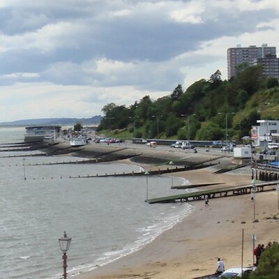
This video reveals what appears to be sewage flowing... into water on Southend seafront. The footage was captured on Sunday. The area of darker coloured water was spotted by a man in an aircraft who labelled it “disgraceful”. Mark Hutley said: “I’ve never seen anything like it. It could be seen for miles.” It was spotted between Chalkwell beach and Westcliff beach. The apparent sewage spill is close to one of Anglian Water’s ‘storm overflow’ pipes that leads into the water from the land. Latest records indicate that it was active on Sunday 8 September and emptying into the area of the Thames Estuary for a period of time. Anglian Water have a permit from the Environment Agency to operate the storm overflow pipe, which specifies conditions for controlled sewage and stormwater spills during heavy rainfall. This is in order to prevent flooding in homes and businesses when the sewer network becomes overloaded with rainwater.show more
Your Southend
148,736 Aufrufe • vor 2 Jahren
🚨 People across the South need to start preparing... for a potentially HISTORIC Winter Storm this weekend. 🧊Models continues to point toward a Major Ice Storm combined with a multi day period of Snow and Freezing Rain, with wintry precipitation lasting from Friday into Monday morning in some areas. That duration alone raises MASSIVE red flags. 📊 Nearly every major weather model and its ensembles are now on board with this scenario, showing widespread Ice Accumulations that could reach 0.5 to 1 inch in spots. Anything over 0.25 inches is destructive, with a high risk of widespread power outages and roads that are undrivable. 🌨️ Snow Totals could also be significant, with areas that normally see NO SNOW ALL YEAR, picking up 6 inches or significantly more in parts of the South. 📍 The areas most at risk include Texas, Oklahoma, Arkansas, Louisiana, Mississippi, Tennessee, Alabama, Georgia, the Carolinas, and Virginia. This is a serious setup with the potential for long lasting and far reaching impacts. I would start at least coming up with a plan in case roads are hazardous this weekend. 👀 I’ll stay on this closely, my brotheren.show more
Brady Harris
206,757 Aufrufe • vor 7 Monaten
It seems that there's no English sub for this... part of Lada's narration in The Water EP8. This is a rough translation in case you want to know what she said. --- After going through many incidents like the sea being hit by a storm, the sky has turned bright blue with the sun warmly shining. Even at night, there's the moon and the sky keeping company with the sea. This is like a woman’s love, the woman whom everyone sees as a workaholic and now has been deeply in love since “that person” has held her hand and never let go ever since. Someone said that if grains of sand could turn into sugar, the taste of seawater could become gently sweet too. And even the waves would be carried ashore by love. THE WATER FINAL EPISODE #นทีร้อยเล่ห์ตอนจบshow more

Me_Myself_and_I
27,544 Aufrufe • vor 3 Monaten